You are here: Home > Network List > TA - USArray Transportable Network (new EarthScope stations) Stations List
> Station S39A Bolivar, MO, USA > Earthquake Result Viewer
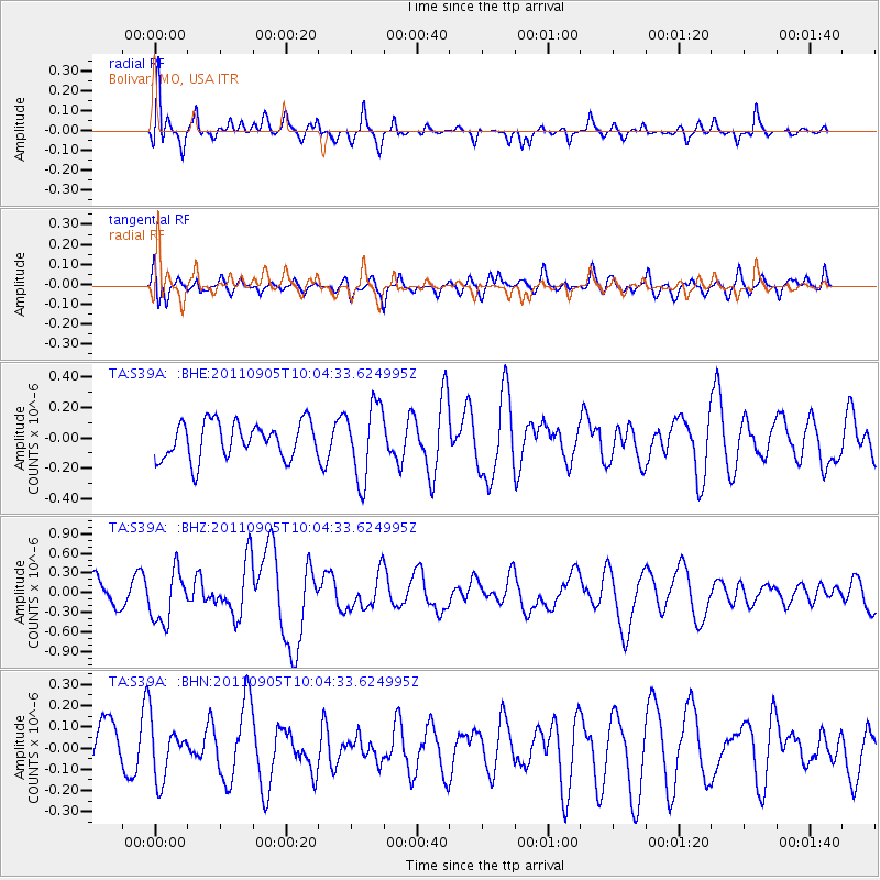
S39A Bolivar, MO, USA - Earthquake Result Viewer
*The percent match for this event was below the threshold and hence no stack was calculated.
| Earthquake location: |
Tonga Islands |
| Earthquake latitude/longitude: |
-15.3/-173.6 |
| Earthquake time(UTC): |
2011/09/05 (248) 09:52:01 GMT |
| Earthquake Depth: |
37 km |
| Earthquake Magnitude: |
6.2 MB, 6.2 MS, 6.3 MW, 6.2 MW |
| Earthquake Catalog/Contributor: |
WHDF/NEIC |
|
| Network: |
TA USArray Transportable Network (new EarthScope stations) |
| Station: |
S39A Bolivar, MO, USA |
| Lat/Lon: |
37.69 N/93.32 W |
| Elevation: |
331 m |
|
| Distance: |
91.8 deg |
| Az: |
51.474 deg |
| Baz: |
252.115 deg |
| Ray Param: |
$rayparam |
*The percent match for this event was below the threshold and hence was not used in the summary stack. |
|
| Radial Match: |
60.843056 % |
| Radial Bump: |
400 |
| Transverse Match: |
50.82919 % |
| Transverse Bump: |
400 |
| SOD ConfigId: |
414626 |
| Insert Time: |
2012-01-20 11:34:11.884 +0000 |
| GWidth: |
2.5 |
| Max Bumps: |
400 |
| Tol: |
0.001 |
|
Signal To Noise
| Channel | StoN | STA | LTA |
| TA:S39A: :BHZ:20110905T10:04:33.624995Z | 2.427197 | 3.9686086E-7 | 1.6350583E-7 |
| TA:S39A: :BHN:20110905T10:04:33.624995Z | 1.2676883 | 1.3100976E-7 | 1.0334541E-7 |
| TA:S39A: :BHE:20110905T10:04:33.624995Z | 2.0411375 | 2.438816E-7 | 1.1948319E-7 |
| Arrivals |
| Ps | |
| PpPs | |
| PsPs/PpSs | |


