You are here: Home > Network List > TA - USArray Transportable Network (new EarthScope stations) Stations List
> Station S38A Stockton, MO, USA > Earthquake Result Viewer
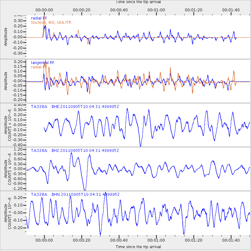
S38A Stockton, MO, USA - Earthquake Result Viewer
*The percent match for this event was below the threshold and hence no stack was calculated.
| Earthquake location: |
Tonga Islands |
| Earthquake latitude/longitude: |
-15.3/-173.6 |
| Earthquake time(UTC): |
2011/09/05 (248) 09:52:01 GMT |
| Earthquake Depth: |
37 km |
| Earthquake Magnitude: |
6.2 MB, 6.2 MS, 6.3 MW, 6.2 MW |
| Earthquake Catalog/Contributor: |
WHDF/NEIC |
|
| Network: |
TA USArray Transportable Network (new EarthScope stations) |
| Station: |
S38A Stockton, MO, USA |
| Lat/Lon: |
37.63 N/93.91 W |
| Elevation: |
294 m |
|
| Distance: |
91.3 deg |
| Az: |
51.387 deg |
| Baz: |
251.761 deg |
| Ray Param: |
$rayparam |
*The percent match for this event was below the threshold and hence was not used in the summary stack. |
|
| Radial Match: |
71.33432 % |
| Radial Bump: |
363 |
| Transverse Match: |
48.803577 % |
| Transverse Bump: |
400 |
| SOD ConfigId: |
414626 |
| Insert Time: |
2012-01-20 11:34:44.684 +0000 |
| GWidth: |
2.5 |
| Max Bumps: |
400 |
| Tol: |
0.001 |
|
Signal To Noise
| Channel | StoN | STA | LTA |
| TA:S38A: :BHZ:20110905T10:04:31.499995Z | 2.761142 | 4.2322512E-7 | 1.5327902E-7 |
| TA:S38A: :BHN:20110905T10:04:31.499995Z | 0.7941046 | 1.1673776E-7 | 1.4700552E-7 |
| TA:S38A: :BHE:20110905T10:04:31.499995Z | 1.020407 | 1.15806124E-7 | 1.1349014E-7 |
| Arrivals |
| Ps | |
| PpPs | |
| PsPs/PpSs | |


