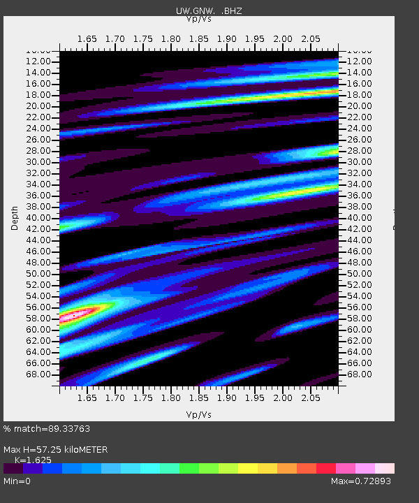
GNW Green Mountain (BB) - Earthquake Result Viewer

Earthquake location: Tonga Islands
Earthquake latitude/longitude: -15.3/-173.6
Earthquake time(UTC): 2011/09/05 (248) 09:52:01 GMT
Earthquake Depth: 37 km
Earthquake Magnitude: 6.2 MB, 6.2 MS, 6.3 MW, 6.2 MW
Earthquake Catalog/Contributor: WHDF/NEIC
Network: UW Pacific Northwest Regional Seismic Network
Station: GNW Green Mountain (BB)
Lat/Lon: 47.56 N/122.83 W
Elevation: 160 m
Distance: 77.3 deg
Az: 32.547 deg
Baz: 230.051 deg
Ray Param: 0.05037482
Estimated Moho Depth: 57.25 km
Estimated Crust Vp/Vs: 1.62
Assumed Crust Vp: 6.566 km/s
Estimated Crust Vs: 4.041 km/s
Estimated Crust Poisson's Ratio: 0.20
Radial Match: 89.33763 %
Radial Bump: 400
Transverse Match: 78.8563 %
Transverse Bump: 400
SOD ConfigId: 414626
Insert Time: 2012-01-20 11:48:28.331 +0000
GWidth: 2.5
Max Bumps: 400
Tol: 0.001

Signal To Noise

ChannelStoNSTALTA
UW:GNW: :BHZ:20110905T10:03:20.664973Z16.550281.7223044E-61.0406498E-7
UW:GNW: :BHN:20110905T10:03:20.664973Z3.97553686.612588E-71.6633194E-7
UW:GNW: :BHE:20110905T10:03:20.664973Z4.35008573.571321E-78.209771E-8
Arrivals
Ps5.6 SECOND
PpPs22 SECOND
PsPs/PpSs28 SECOND