You are here: Home > Network List > TA - USArray Transportable Network (new EarthScope stations) Stations List
> Station S37A Fort Scott, KS, USA > Earthquake Result Viewer
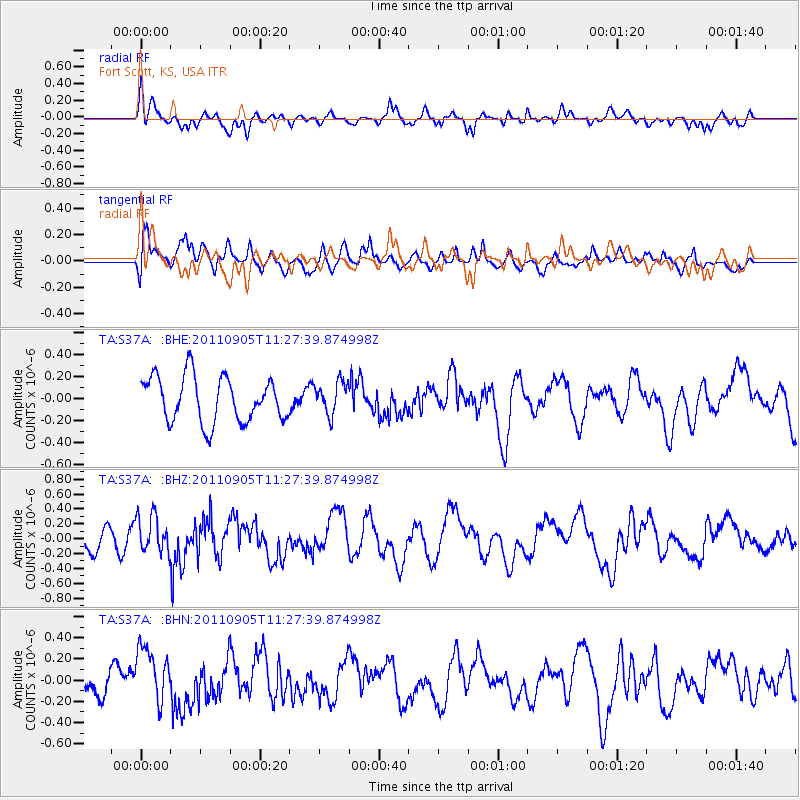
S37A Fort Scott, KS, USA - Earthquake Result Viewer
*The percent match for this event was below the threshold and hence no stack was calculated.
| Earthquake location: |
South Of Panama |
| Earthquake latitude/longitude: |
6.6/-82.4 |
| Earthquake time(UTC): |
2011/09/05 (248) 11:21:36 GMT |
| Earthquake Depth: |
25 km |
| Earthquake Magnitude: |
5.8 MW, 5.2 MS, 5.3 MB, 5.8 MW |
| Earthquake Catalog/Contributor: |
WHDF/NEIC |
|
| Network: |
TA USArray Transportable Network (new EarthScope stations) |
| Station: |
S37A Fort Scott, KS, USA |
| Lat/Lon: |
37.76 N/94.83 W |
| Elevation: |
260 m |
|
| Distance: |
33.1 deg |
| Az: |
341.716 deg |
| Baz: |
156.842 deg |
| Ray Param: |
$rayparam |
*The percent match for this event was below the threshold and hence was not used in the summary stack. |
|
| Radial Match: |
64.14118 % |
| Radial Bump: |
400 |
| Transverse Match: |
64.09913 % |
| Transverse Bump: |
400 |
| SOD ConfigId: |
414626 |
| Insert Time: |
2012-01-20 12:13:45.159 +0000 |
| GWidth: |
2.5 |
| Max Bumps: |
400 |
| Tol: |
0.001 |
|
Signal To Noise
| Channel | StoN | STA | LTA |
| TA:S37A: :BHZ:20110905T11:27:39.874998Z | 1.1834371 | 2.5433366E-7 | 2.14911E-7 |
| TA:S37A: :BHN:20110905T11:27:39.874998Z | 2.1591554 | 2.664285E-7 | 1.2339478E-7 |
| TA:S37A: :BHE:20110905T11:27:39.874998Z | 0.71719414 | 1.4580914E-7 | 2.0330496E-7 |
| Arrivals |
| Ps | |
| PpPs | |
| PsPs/PpSs | |


