You are here: Home > Network List > TA - USArray Transportable Network (new EarthScope stations) Stations List
> Station K37A Belmond, IA, USA > Earthquake Result Viewer
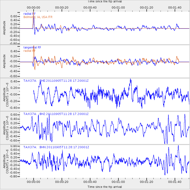
K37A Belmond, IA, USA - Earthquake Result Viewer
*The percent match for this event was below the threshold and hence no stack was calculated.
| Earthquake location: |
South Of Panama |
| Earthquake latitude/longitude: |
6.6/-82.4 |
| Earthquake time(UTC): |
2011/09/05 (248) 11:21:36 GMT |
| Earthquake Depth: |
25 km |
| Earthquake Magnitude: |
5.8 MW, 5.2 MS, 5.3 MB, 5.8 MW |
| Earthquake Catalog/Contributor: |
WHDF/NEIC |
|
| Network: |
TA USArray Transportable Network (new EarthScope stations) |
| Station: |
K37A Belmond, IA, USA |
| Lat/Lon: |
42.77 N/93.64 W |
| Elevation: |
365 m |
|
| Distance: |
37.4 deg |
| Az: |
346.283 deg |
| Baz: |
161.342 deg |
| Ray Param: |
$rayparam |
*The percent match for this event was below the threshold and hence was not used in the summary stack. |
|
| Radial Match: |
63.33521 % |
| Radial Bump: |
400 |
| Transverse Match: |
60.958958 % |
| Transverse Bump: |
400 |
| SOD ConfigId: |
414626 |
| Insert Time: |
2012-01-20 12:17:05.519 +0000 |
| GWidth: |
2.5 |
| Max Bumps: |
400 |
| Tol: |
0.001 |
|
Signal To Noise
| Channel | StoN | STA | LTA |
| TA:K37A: :BHZ:20110905T11:28:17.20001Z | 1.8904663 | 2.8935585E-7 | 1.5306057E-7 |
| TA:K37A: :BHN:20110905T11:28:17.20001Z | 2.0039165 | 2.4915988E-7 | 1.2433647E-7 |
| TA:K37A: :BHE:20110905T11:28:17.20001Z | 0.7010292 | 1.1728924E-7 | 1.6731006E-7 |
| Arrivals |
| Ps | |
| PpPs | |
| PsPs/PpSs | |


