You are here: Home > Network List > TA - USArray Transportable Network (new EarthScope stations) Stations List
> Station L36A Harm Buss Farm, Glidden, IA, USA > Earthquake Result Viewer
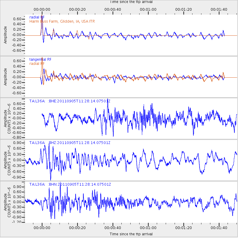
L36A Harm Buss Farm, Glidden, IA, USA - Earthquake Result Viewer
*The percent match for this event was below the threshold and hence no stack was calculated.
| Earthquake location: |
South Of Panama |
| Earthquake latitude/longitude: |
6.6/-82.4 |
| Earthquake time(UTC): |
2011/09/05 (248) 11:21:36 GMT |
| Earthquake Depth: |
25 km |
| Earthquake Magnitude: |
5.8 MW, 5.2 MS, 5.3 MB, 5.8 MW |
| Earthquake Catalog/Contributor: |
WHDF/NEIC |
|
| Network: |
TA USArray Transportable Network (new EarthScope stations) |
| Station: |
L36A Harm Buss Farm, Glidden, IA, USA |
| Lat/Lon: |
42.10 N/94.67 W |
| Elevation: |
353 m |
|
| Distance: |
37.0 deg |
| Az: |
344.728 deg |
| Baz: |
159.412 deg |
| Ray Param: |
$rayparam |
*The percent match for this event was below the threshold and hence was not used in the summary stack. |
|
| Radial Match: |
64.15127 % |
| Radial Bump: |
400 |
| Transverse Match: |
60.202667 % |
| Transverse Bump: |
400 |
| SOD ConfigId: |
414626 |
| Insert Time: |
2012-01-20 12:17:44.017 +0000 |
| GWidth: |
2.5 |
| Max Bumps: |
400 |
| Tol: |
0.001 |
|
Signal To Noise
| Channel | StoN | STA | LTA |
| TA:L36A: :BHZ:20110905T11:28:14.07501Z | 2.4636388 | 4.729E-7 | 1.9195184E-7 |
| TA:L36A: :BHN:20110905T11:28:14.07501Z | 2.2199476 | 2.9420042E-7 | 1.3252584E-7 |
| TA:L36A: :BHE:20110905T11:28:14.07501Z | 1.520067 | 2.4960372E-7 | 1.6420573E-7 |
| Arrivals |
| Ps | |
| PpPs | |
| PsPs/PpSs | |


