You are here: Home > Network List > TA - USArray Transportable Network (new EarthScope stations) Stations List
> Station N42A Yates City, IL, USA > Earthquake Result Viewer
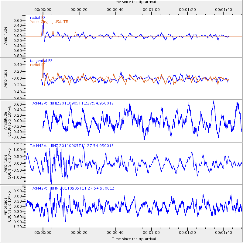
N42A Yates City, IL, USA - Earthquake Result Viewer
*The percent match for this event was below the threshold and hence no stack was calculated.
| Earthquake location: |
South Of Panama |
| Earthquake latitude/longitude: |
6.6/-82.4 |
| Earthquake time(UTC): |
2011/09/05 (248) 11:21:36 GMT |
| Earthquake Depth: |
25 km |
| Earthquake Magnitude: |
5.8 MW, 5.2 MS, 5.3 MB, 5.8 MW |
| Earthquake Catalog/Contributor: |
WHDF/NEIC |
|
| Network: |
TA USArray Transportable Network (new EarthScope stations) |
| Station: |
N42A Yates City, IL, USA |
| Lat/Lon: |
40.83 N/90.03 W |
| Elevation: |
205 m |
|
| Distance: |
34.8 deg |
| Az: |
349.77 deg |
| Baz: |
166.554 deg |
| Ray Param: |
$rayparam |
*The percent match for this event was below the threshold and hence was not used in the summary stack. |
|
| Radial Match: |
73.76735 % |
| Radial Bump: |
400 |
| Transverse Match: |
76.51841 % |
| Transverse Bump: |
400 |
| SOD ConfigId: |
414626 |
| Insert Time: |
2012-01-20 12:21:17.736 +0000 |
| GWidth: |
2.5 |
| Max Bumps: |
400 |
| Tol: |
0.001 |
|
Signal To Noise
| Channel | StoN | STA | LTA |
| TA:N42A: :BHZ:20110905T11:27:54.95001Z | 2.0271006 | 6.3100373E-7 | 3.1128386E-7 |
| TA:N42A: :BHN:20110905T11:27:54.95001Z | 2.080057 | 4.20813E-7 | 2.0230839E-7 |
| TA:N42A: :BHE:20110905T11:27:54.95001Z | 0.88357455 | 1.9807933E-7 | 2.2417953E-7 |
| Arrivals |
| Ps | |
| PpPs | |
| PsPs/PpSs | |


