You are here: Home > Network List > IU - Global Seismograph Network (GSN - IRIS/USGS) Stations List
> Station TIXI Tiksi, Russia > Earthquake Result Viewer
TIXI Tiksi, Russia - Earthquake Result Viewer
| Earthquake location: |
Northern Sumatra, Indonesia |
| Earthquake latitude/longitude: |
3.0/97.9 |
| Earthquake time(UTC): |
2011/09/05 (248) 17:55:11 GMT |
| Earthquake Depth: |
91 km |
| Earthquake Magnitude: |
6.6 MB, 6.7 MW, 6.7 MW |
| Earthquake Catalog/Contributor: |
WHDF/NEIC |
|
| Network: |
IU Global Seismograph Network (GSN - IRIS/USGS) |
| Station: |
TIXI Tiksi, Russia |
| Lat/Lon: |
71.63 N/128.87 E |
| Elevation: |
40 m |
|
| Distance: |
71.3 deg |
| Az: |
9.916 deg |
| Baz: |
212.855 deg |
| Ray Param: |
0.054181494 |
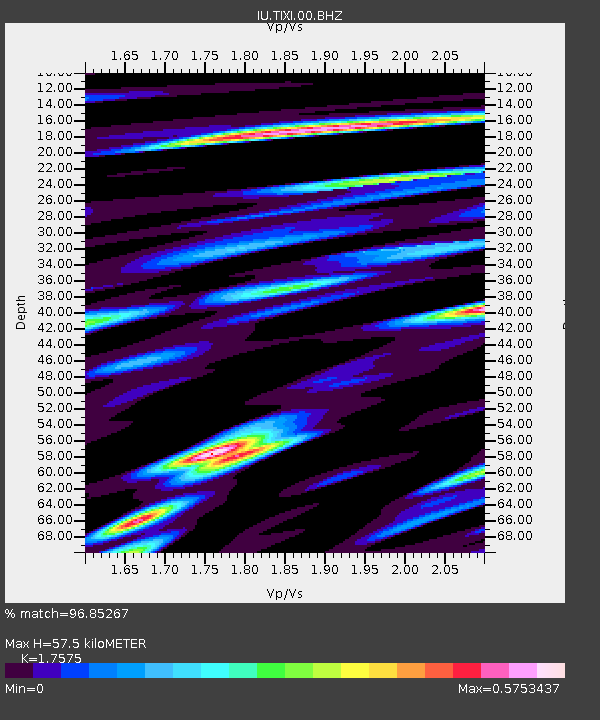
| Estimated Moho Depth: |
57.5 km |
| Estimated Crust Vp/Vs: |
1.76 |
| Assumed Crust Vp: |
6.552 km/s |
| Estimated Crust Vs: |
3.728 km/s |
| Estimated Crust Poisson's Ratio: |
0.26 |
|
| Radial Match: |
96.85267 % |
| Radial Bump: |
341 |
| Transverse Match: |
89.52327 % |
| Transverse Bump: |
400 |
| SOD ConfigId: |
414626 |
| Insert Time: |
2012-01-20 12:37:18.661 +0000 |
| GWidth: |
2.5 |
| Max Bumps: |
400 |
| Tol: |
0.001 |
|
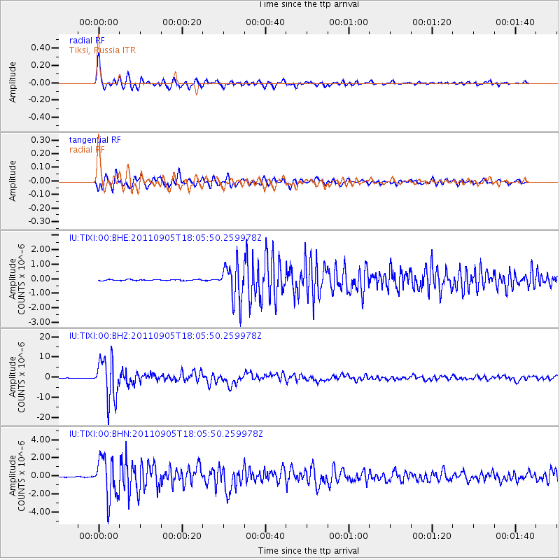
Signal To Noise
| Channel | StoN | STA | LTA |
| IU:TIXI:00:BHZ:20110905T18:05:50.259978Z | 126.63648 | 1.0314582E-5 | 8.1450324E-8 |
| IU:TIXI:00:BHN:20110905T18:05:50.259978Z | 75.43955 | 2.3222372E-6 | 3.0782754E-8 |
| IU:TIXI:00:BHE:20110905T18:05:50.259978Z | 39.42917 | 1.2790562E-6 | 3.243934E-8 |
| Arrivals |
| Ps | 6.9 SECOND |
| PpPs | 23 SECOND |
| PsPs/PpSs | 30 SECOND |


