You are here: Home > Network List > MN - MEDNET Project Stations List
> Station IDI Anogia, Greece > Earthquake Result Viewer
IDI Anogia, Greece - Earthquake Result Viewer

| Earthquake location: |
Northern Sumatra, Indonesia |
| Earthquake latitude/longitude: |
3.0/97.9 |
| Earthquake time(UTC): |
2011/09/05 (248) 17:55:11 GMT |
| Earthquake Depth: |
91 km |
| Earthquake Magnitude: |
6.6 MB, 6.7 MW, 6.7 MW |
| Earthquake Catalog/Contributor: |
WHDF/NEIC |
|
| Network: |
MN MEDNET Project |
| Station: |
IDI Anogia, Greece |
| Lat/Lon: |
35.29 N/24.89 E |
| Elevation: |
750 m |
|
| Distance: |
74.4 deg |
| Az: |
305.694 deg |
| Baz: |
97.507 deg |
| Ray Param: |
0.05212523 |
| Estimated Moho Depth: |
55.25 km |
| Estimated Crust Vp/Vs: |
1.67 |
| Assumed Crust Vp: |
5.627 km/s |
| Estimated Crust Vs: |
3.374 km/s |
| Estimated Crust Poisson's Ratio: |
0.22 |
|
| Radial Match: |
86.140915 % |
| Radial Bump: |
400 |
| Transverse Match: |
83.29789 % |
| Transverse Bump: |
400 |
| SOD ConfigId: |
414626 |
| Insert Time: |
2012-01-20 12:39:10.320 +0000 |
| GWidth: |
2.5 |
| Max Bumps: |
400 |
| Tol: |
0.001 |
|
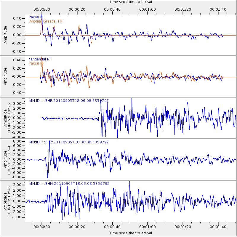
Signal To Noise
| Channel | StoN | STA | LTA |
| MN:IDI: :BHZ:20110905T18:06:08.535979Z | 20.970673 | 3.3524825E-6 | 1.5986528E-7 |
| MN:IDI: :BHN:20110905T18:06:08.535979Z | 4.503725 | 6.8240615E-7 | 1.5152038E-7 |
| MN:IDI: :BHE:20110905T18:06:08.535979Z | 14.480736 | 1.4439839E-6 | 9.971758E-8 |
| Arrivals |
| Ps | 6.7 SECOND |
| PpPs | 26 SECOND |
| PsPs/PpSs | 32 SECOND |


