You are here: Home > Network List > MN - MEDNET Project Stations List
> Station VTS Vitosha, Bulgary > Earthquake Result Viewer
VTS Vitosha, Bulgary - Earthquake Result Viewer
| Earthquake location: |
Northern Sumatra, Indonesia |
| Earthquake latitude/longitude: |
3.0/97.9 |
| Earthquake time(UTC): |
2011/09/05 (248) 17:55:11 GMT |
| Earthquake Depth: |
91 km |
| Earthquake Magnitude: |
6.6 MB, 6.7 MW, 6.7 MW |
| Earthquake Catalog/Contributor: |
WHDF/NEIC |
|
| Network: |
MN MEDNET Project |
| Station: |
VTS Vitosha, Bulgary |
| Lat/Lon: |
42.62 N/23.24 E |
| Elevation: |
1490 m |
|
| Distance: |
76.7 deg |
| Az: |
312.996 deg |
| Baz: |
98.29 deg |
| Ray Param: |
0.050600346 |
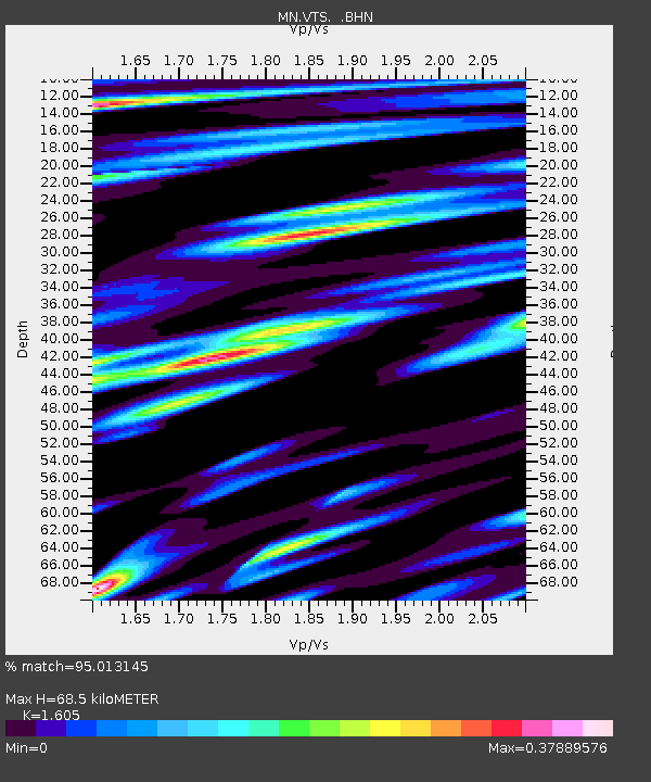
| Estimated Moho Depth: |
68.5 km |
| Estimated Crust Vp/Vs: |
1.61 |
| Assumed Crust Vp: |
6.291 km/s |
| Estimated Crust Vs: |
3.92 km/s |
| Estimated Crust Poisson's Ratio: |
0.18 |
|
| Radial Match: |
95.013145 % |
| Radial Bump: |
400 |
| Transverse Match: |
92.73734 % |
| Transverse Bump: |
400 |
| SOD ConfigId: |
414626 |
| Insert Time: |
2012-01-20 12:39:17.056 +0000 |
| GWidth: |
2.5 |
| Max Bumps: |
400 |
| Tol: |
0.001 |
|

Signal To Noise
| Channel | StoN | STA | LTA |
| MN:VTS: :BHZ:20110905T18:06:21.55197Z | 67.19442 | 2.9223024E-6 | 4.349025E-8 |
| MN:VTS: :BHN:20110905T18:06:21.55197Z | 22.118925 | 5.109502E-7 | 2.3100137E-8 |
| MN:VTS: :BHE:20110905T18:06:21.55197Z | 23.906855 | 7.4171913E-7 | 3.1025376E-8 |
| Arrivals |
| Ps | 6.8 SECOND |
| PpPs | 27 SECOND |
| PsPs/PpSs | 34 SECOND |


