You are here: Home > Network List > TA - USArray Transportable Network (new EarthScope stations) Stations List
> Station TOLK Tollok Lake Research Station, AK, USA > Earthquake Result Viewer
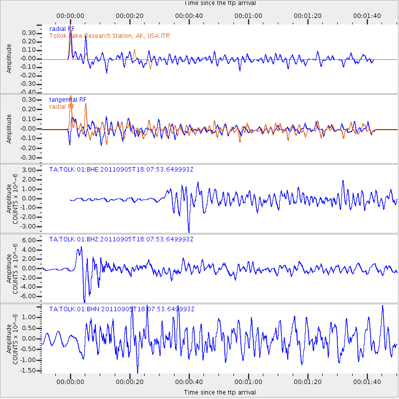
TOLK Tollok Lake Research Station, AK, USA - Earthquake Result Viewer
| Earthquake location: |
Northern Sumatra, Indonesia |
| Earthquake latitude/longitude: |
3.0/97.9 |
| Earthquake time(UTC): |
2011/09/05 (248) 17:55:11 GMT |
| Earthquake Depth: |
91 km |
| Earthquake Magnitude: |
6.6 MB, 6.7 MW, 6.7 MW |
| Earthquake Catalog/Contributor: |
WHDF/NEIC |
|
| Network: |
TA USArray Transportable Network (new EarthScope stations) |
| Station: |
TOLK Tollok Lake Research Station, AK, USA |
| Lat/Lon: |
68.64 N/149.57 W |
| Elevation: |
760 m |
|
| Distance: |
95.3 deg |
| Az: |
19.866 deg |
| Baz: |
292.121 deg |
| Ray Param: |
0.040755335 |
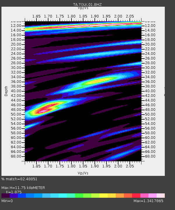
| Estimated Moho Depth: |
11.75 km |
| Estimated Crust Vp/Vs: |
1.88 |
| Assumed Crust Vp: |
6.316 km/s |
| Estimated Crust Vs: |
3.369 km/s |
| Estimated Crust Poisson's Ratio: |
0.30 |
|
| Radial Match: |
82.48851 % |
| Radial Bump: |
400 |
| Transverse Match: |
79.941345 % |
| Transverse Bump: |
400 |
| SOD ConfigId: |
414626 |
| Insert Time: |
2012-01-20 12:41:29.172 +0000 |
| GWidth: |
2.5 |
| Max Bumps: |
400 |
| Tol: |
0.001 |
|
Signal To Noise
| Channel | StoN | STA | LTA |
| TA:TOLK:01:BHZ:20110905T18:07:53.649993Z | 13.236351 | 3.021469E-6 | 2.2827054E-7 |
| TA:TOLK:01:BHN:20110905T18:07:53.649993Z | 2.3173761 | 4.186629E-7 | 1.8066247E-7 |
| TA:TOLK:01:BHE:20110905T18:07:53.649993Z | 5.795598 | 6.235899E-7 | 1.0759717E-7 |
| Arrivals |
| Ps | 1.7 SECOND |
| PpPs | 5.3 SECOND |
| PsPs/PpSs | 6.9 SECOND |


