You are here: Home > Network List > TW - Broadband Array in Taiwan for Seismology Stations List
> Station SSLB SUANG-LONG > Earthquake Result Viewer
SSLB SUANG-LONG - Earthquake Result Viewer
| Earthquake location: |
Northern Sumatra, Indonesia |
| Earthquake latitude/longitude: |
3.0/97.9 |
| Earthquake time(UTC): |
2011/09/05 (248) 17:55:11 GMT |
| Earthquake Depth: |
91 km |
| Earthquake Magnitude: |
6.6 MB, 6.7 MW, 6.7 MW |
| Earthquake Catalog/Contributor: |
WHDF/NEIC |
|
| Network: |
TW Broadband Array in Taiwan for Seismology |
| Station: |
SSLB SUANG-LONG |
| Lat/Lon: |
23.79 N/120.95 E |
| Elevation: |
450 m |
|
| Distance: |
30.4 deg |
| Az: |
45.126 deg |
| Baz: |
230.587 deg |
| Ray Param: |
0.07919066 |
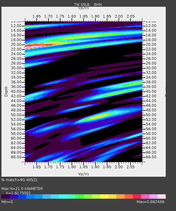
| Estimated Moho Depth: |
21.0 km |
| Estimated Crust Vp/Vs: |
1.62 |
| Assumed Crust Vp: |
6.461 km/s |
| Estimated Crust Vs: |
3.995 km/s |
| Estimated Crust Poisson's Ratio: |
0.19 |
|
| Radial Match: |
90.48521 % |
| Radial Bump: |
345 |
| Transverse Match: |
75.405975 % |
| Transverse Bump: |
400 |
| SOD ConfigId: |
414626 |
| Insert Time: |
2012-01-20 12:41:41.624 +0000 |
| GWidth: |
2.5 |
| Max Bumps: |
400 |
| Tol: |
0.001 |
|

Signal To Noise
| Channel | StoN | STA | LTA |
| TW:SSLB: :BHZ:20110905T18:00:44.769988Z | 42.959824 | 7.597757E-6 | 1.7685726E-7 |
| TW:SSLB: :BHN:20110905T18:00:44.769988Z | 17.798737 | 2.56412E-6 | 1.4406191E-7 |
| TW:SSLB: :BHE:20110905T18:00:44.769988Z | 24.191624 | 3.4943685E-6 | 1.444454E-7 |
| Arrivals |
| Ps | 2.2 SECOND |
| PpPs | 7.8 SECOND |
| PsPs/PpSs | 10.0 SECOND |


