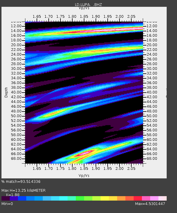
LUPA Lehigh University, PA - Earthquake Result Viewer

Earthquake location: Vancouver Island, Canada Region
Earthquake latitude/longitude: 49.5/-126.9
Earthquake time(UTC): 2011/09/09 (252) 19:41:34 GMT
Earthquake Depth: 22 km
Earthquake Magnitude: 6.3 MB, 6.4 MS, 6.4 MW, 6.5 MW
Earthquake Catalog/Contributor: WHDF/NEIC
Network: LD Lamont-Doherty Cooperative Seismographic Network
Station: LUPA Lehigh University, PA
Lat/Lon: 40.60 N/75.37 W
Elevation: 236 m
Distance: 36.8 deg
Az: 83.977 deg
Baz: 301.691 deg
Ray Param: 0.0764388
Estimated Moho Depth: 13.25 km
Estimated Crust Vp/Vs: 1.98
Assumed Crust Vp: 6.283 km/s
Estimated Crust Vs: 3.173 km/s
Estimated Crust Poisson's Ratio: 0.33
Radial Match: 93.514336 %
Radial Bump: 293
Transverse Match: 93.56833 %
Transverse Bump: 287
SOD ConfigId: 414626
Insert Time: 2012-01-20 12:49:42.132 +0000
GWidth: 2.5
Max Bumps: 400
Tol: 0.001

Signal To Noise

ChannelStoNSTALTA
LD:LUPA: :BHZ:20110909T19:48:09.799994Z14.8764644.7072447E-73.164223E-8
LD:LUPA: :BHN:20110909T19:48:09.799994Z0.906489253.4833563E-93.842689E-9
LD:LUPA: :BHE:20110909T19:48:09.799994Z7.6788441.4085067E-61.8342693E-7
Arrivals
Ps2.2 SECOND
PpPs5.9 SECOND
PsPs/PpSs8.1 SECOND