You are here: Home > Network List > TA - USArray Transportable Network (new EarthScope stations) Stations List
> Station N54A Moraine State Park, Portersville, PA, USA > Earthquake Result Viewer
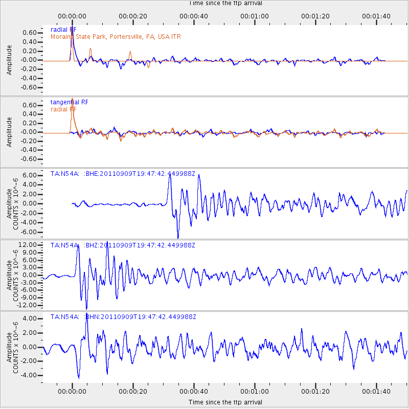
N54A Moraine State Park, Portersville, PA, USA - Earthquake Result Viewer
| Earthquake location: |
Vancouver Island, Canada Region |
| Earthquake latitude/longitude: |
49.5/-126.9 |
| Earthquake time(UTC): |
2011/09/09 (252) 19:41:34 GMT |
| Earthquake Depth: |
22 km |
| Earthquake Magnitude: |
6.3 MB, 6.4 MS, 6.4 MW, 6.5 MW |
| Earthquake Catalog/Contributor: |
WHDF/NEIC |
|
| Network: |
TA USArray Transportable Network (new EarthScope stations) |
| Station: |
N54A Moraine State Park, Portersville, PA, USA |
| Lat/Lon: |
40.96 N/79.99 W |
| Elevation: |
408 m |
|
| Distance: |
33.6 deg |
| Az: |
86.593 deg |
| Baz: |
300.823 deg |
| Ray Param: |
0.078088194 |
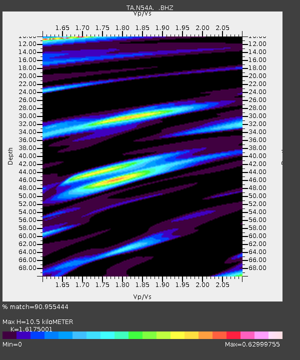
| Estimated Moho Depth: |
10.5 km |
| Estimated Crust Vp/Vs: |
1.62 |
| Assumed Crust Vp: |
6.121 km/s |
| Estimated Crust Vs: |
3.784 km/s |
| Estimated Crust Poisson's Ratio: |
0.19 |
|
| Radial Match: |
90.955444 % |
| Radial Bump: |
400 |
| Transverse Match: |
78.996895 % |
| Transverse Bump: |
400 |
| SOD ConfigId: |
414626 |
| Insert Time: |
2012-01-20 12:55:34.694 +0000 |
| GWidth: |
2.5 |
| Max Bumps: |
400 |
| Tol: |
0.001 |
|
Signal To Noise
| Channel | StoN | STA | LTA |
| TA:N54A: :BHZ:20110909T19:47:42.449988Z | 11.273231 | 6.3463735E-6 | 5.629596E-7 |
| TA:N54A: :BHN:20110909T19:47:42.449988Z | 5.2829857 | 2.128019E-6 | 4.0280617E-7 |
| TA:N54A: :BHE:20110909T19:47:42.449988Z | 12.624699 | 3.1078164E-6 | 2.4616955E-7 |
| Arrivals |
| Ps | 1.1 SECOND |
| PpPs | 4.2 SECOND |
| PsPs/PpSs | 5.3 SECOND |


