You are here: Home > Network List > TA - USArray Transportable Network (new EarthScope stations) Stations List
> Station 245A Little AP, Star, MS, USA > Earthquake Result Viewer
245A Little AP, Star, MS, USA - Earthquake Result Viewer
| Earthquake location: |
Vancouver Island, Canada Region |
| Earthquake latitude/longitude: |
49.5/-126.9 |
| Earthquake time(UTC): |
2011/09/09 (252) 19:41:34 GMT |
| Earthquake Depth: |
22 km |
| Earthquake Magnitude: |
6.3 MB, 6.4 MS, 6.4 MW, 6.5 MW |
| Earthquake Catalog/Contributor: |
WHDF/NEIC |
|
| Network: |
TA USArray Transportable Network (new EarthScope stations) |
| Station: |
245A Little AP, Star, MS, USA |
| Lat/Lon: |
32.03 N/89.90 W |
| Elevation: |
104 m |
|
| Distance: |
32.6 deg |
| Az: |
108.471 deg |
| Baz: |
313.319 deg |
| Ray Param: |
0.07855549 |
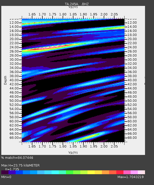
| Estimated Moho Depth: |
23.75 km |
| Estimated Crust Vp/Vs: |
1.74 |
| Assumed Crust Vp: |
6.201 km/s |
| Estimated Crust Vs: |
3.574 km/s |
| Estimated Crust Poisson's Ratio: |
0.25 |
|
| Radial Match: |
84.07446 % |
| Radial Bump: |
400 |
| Transverse Match: |
77.873436 % |
| Transverse Bump: |
400 |
| SOD ConfigId: |
414626 |
| Insert Time: |
2012-01-20 12:58:00.968 +0000 |
| GWidth: |
2.5 |
| Max Bumps: |
400 |
| Tol: |
0.001 |
|
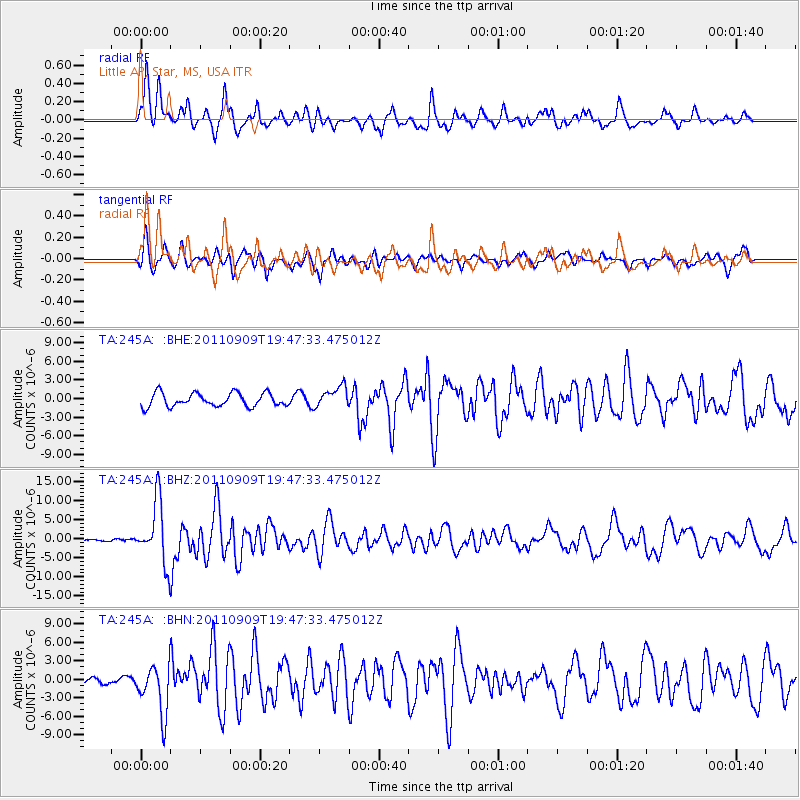
Signal To Noise
| Channel | StoN | STA | LTA |
| TA:245A: :BHZ:20110909T19:47:33.475012Z | 22.160427 | 7.997437E-6 | 3.6088824E-7 |
| TA:245A: :BHN:20110909T19:47:33.475012Z | 5.926348 | 4.003034E-6 | 6.7546387E-7 |
| TA:245A: :BHE:20110909T19:47:33.475012Z | 1.5620584 | 1.6942228E-6 | 1.084609E-6 |
| Arrivals |
| Ps | 3.0 SECOND |
| PpPs | 9.7 SECOND |
| PsPs/PpSs | 13 SECOND |


