You are here: Home > Network List > TA - USArray Transportable Network (new EarthScope stations) Stations List
> Station Y45A Yeager Farm, Coffeeville, MS, USA > Earthquake Result Viewer
Y45A Yeager Farm, Coffeeville, MS, USA - Earthquake Result Viewer
| Earthquake location: |
Vancouver Island, Canada Region |
| Earthquake latitude/longitude: |
49.5/-126.9 |
| Earthquake time(UTC): |
2011/09/09 (252) 19:41:34 GMT |
| Earthquake Depth: |
22 km |
| Earthquake Magnitude: |
6.3 MB, 6.4 MS, 6.4 MW, 6.5 MW |
| Earthquake Catalog/Contributor: |
WHDF/NEIC |
|
| Network: |
TA USArray Transportable Network (new EarthScope stations) |
| Station: |
Y45A Yeager Farm, Coffeeville, MS, USA |
| Lat/Lon: |
33.87 N/89.54 W |
| Elevation: |
106 m |
|
| Distance: |
31.6 deg |
| Az: |
105.547 deg |
| Baz: |
311.032 deg |
| Ray Param: |
0.07898401 |
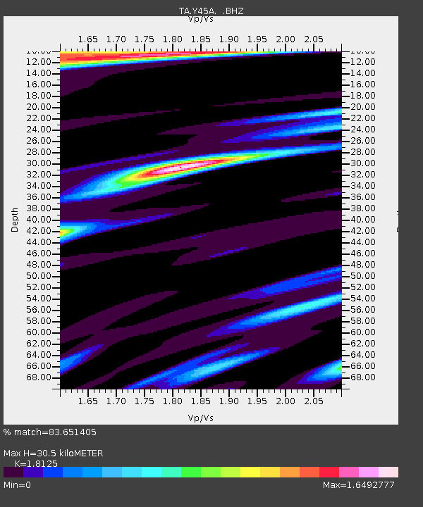
| Estimated Moho Depth: |
30.5 km |
| Estimated Crust Vp/Vs: |
1.81 |
| Assumed Crust Vp: |
6.201 km/s |
| Estimated Crust Vs: |
3.422 km/s |
| Estimated Crust Poisson's Ratio: |
0.28 |
|
| Radial Match: |
83.651405 % |
| Radial Bump: |
321 |
| Transverse Match: |
80.98235 % |
| Transverse Bump: |
400 |
| SOD ConfigId: |
414626 |
| Insert Time: |
2012-01-20 12:59:54.689 +0000 |
| GWidth: |
2.5 |
| Max Bumps: |
400 |
| Tol: |
0.001 |
|
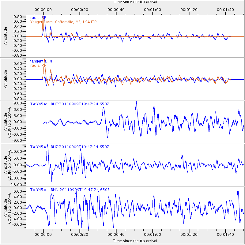
Signal To Noise
| Channel | StoN | STA | LTA |
| TA:Y45A: :BHZ:20110909T19:47:24.650Z | 15.751014 | 6.4664073E-6 | 4.1053912E-7 |
| TA:Y45A: :BHN:20110909T19:47:24.650Z | 3.8128638 | 3.1997806E-6 | 8.392066E-7 |
| TA:Y45A: :BHE:20110909T19:47:24.650Z | 4.7557797 | 3.227125E-6 | 6.785691E-7 |
| Arrivals |
| Ps | 4.3 SECOND |
| PpPs | 13 SECOND |
| PsPs/PpSs | 17 SECOND |


