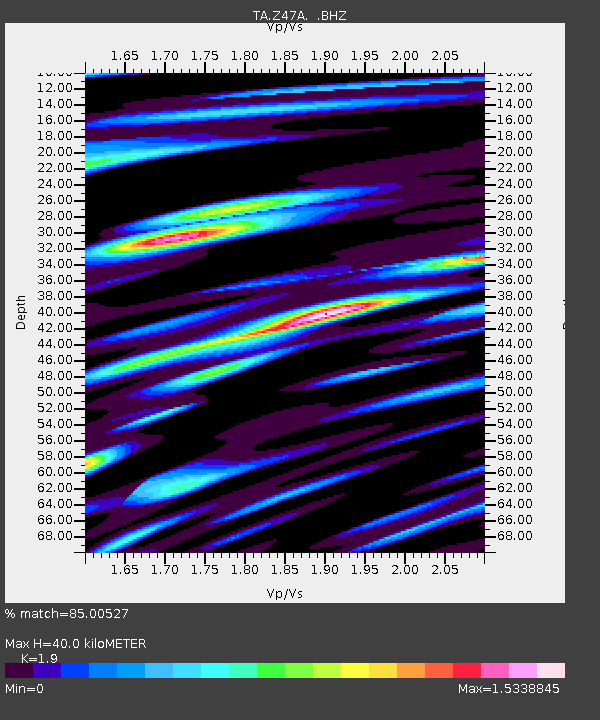
Z47A Carrollton, AL, USA - Earthquake Result Viewer
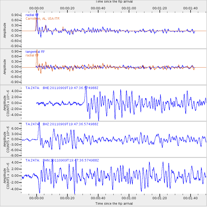
Earthquake location: Vancouver Island, Canada Region
Earthquake latitude/longitude: 49.5/-126.9
Earthquake time(UTC): 2011/09/09 (252) 19:41:34 GMT
Earthquake Depth: 22 km
Earthquake Magnitude: 6.3 MB, 6.4 MS, 6.4 MW, 6.5 MW
Earthquake Catalog/Contributor: WHDF/NEIC
Network: TA USArray Transportable Network (new EarthScope stations)
Station: Z47A Carrollton, AL, USA
Lat/Lon: 33.20 N/88.07 W
Elevation: 65 m
Distance: 33.0 deg
Az: 104.966 deg
Baz: 311.351 deg
Ray Param: 0.078400776
Estimated Moho Depth: 40.0 km
Estimated Crust Vp/Vs: 1.90
Assumed Crust Vp: 6.201 km/s
Estimated Crust Vs: 3.264 km/s
Estimated Crust Poisson's Ratio: 0.31
Radial Match: 85.00527 %
Radial Bump: 400
Transverse Match: 67.13087 %
Transverse Bump: 400
SOD ConfigId: 414626
Insert Time: 2012-01-20 13:00:07.928 +0000
GWidth: 2.5
Max Bumps: 400
Tol: 0.001

Signal To Noise

ChannelStoNSTALTA
TA:Z47A: :BHZ:20110909T19:47:36.574988Z18.2356133.9013885E-62.1394338E-7
TA:Z47A: :BHN:20110909T19:47:36.574988Z8.242512.2649272E-62.7478612E-7
TA:Z47A: :BHE:20110909T19:47:36.574988Z8.7719112.7075798E-63.0866477E-7
Arrivals
Ps6.2 SECOND
PpPs17 SECOND
PsPs/PpSs24 SECOND