You are here: Home > Network List > TA - USArray Transportable Network (new EarthScope stations) Stations List
> Station Z43A Armstrong Family, Eudora, AR, USA > Earthquake Result Viewer
Z43A Armstrong Family, Eudora, AR, USA - Earthquake Result Viewer
| Earthquake location: |
Vancouver Island, Canada Region |
| Earthquake latitude/longitude: |
49.5/-126.9 |
| Earthquake time(UTC): |
2011/09/09 (252) 19:41:34 GMT |
| Earthquake Depth: |
22 km |
| Earthquake Magnitude: |
6.3 MB, 6.4 MS, 6.4 MW, 6.5 MW |
| Earthquake Catalog/Contributor: |
WHDF/NEIC |
|
| Network: |
TA USArray Transportable Network (new EarthScope stations) |
| Station: |
Z43A Armstrong Family, Eudora, AR, USA |
| Lat/Lon: |
33.21 N/91.24 W |
| Elevation: |
39 m |
|
| Distance: |
31.0 deg |
| Az: |
108.308 deg |
| Baz: |
312.456 deg |
| Ray Param: |
0.07917602 |
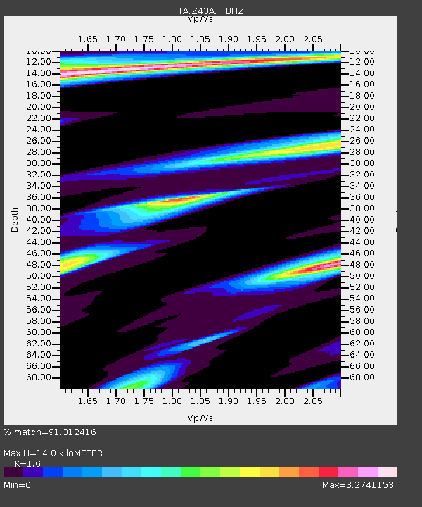
| Estimated Moho Depth: |
14.0 km |
| Estimated Crust Vp/Vs: |
1.60 |
| Assumed Crust Vp: |
6.201 km/s |
| Estimated Crust Vs: |
3.876 km/s |
| Estimated Crust Poisson's Ratio: |
0.18 |
|
| Radial Match: |
91.312416 % |
| Radial Bump: |
325 |
| Transverse Match: |
78.44847 % |
| Transverse Bump: |
400 |
| SOD ConfigId: |
414626 |
| Insert Time: |
2012-01-20 13:00:20.488 +0000 |
| GWidth: |
2.5 |
| Max Bumps: |
400 |
| Tol: |
0.001 |
|
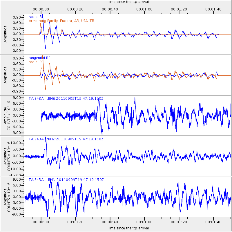
Signal To Noise
| Channel | StoN | STA | LTA |
| TA:Z43A: :BHZ:20110909T19:47:19.150Z | 8.051732 | 5.474775E-6 | 6.7995E-7 |
| TA:Z43A: :BHN:20110909T19:47:19.150Z | 2.822183 | 3.5387636E-6 | 1.2539101E-6 |
| TA:Z43A: :BHE:20110909T19:47:19.150Z | 3.6535587 | 3.6808494E-6 | 1.0074697E-6 |
| Arrivals |
| Ps | 1.5 SECOND |
| PpPs | 5.4 SECOND |
| PsPs/PpSs | 6.9 SECOND |


