X44A Crenshaw, MS, USA - Earthquake Result Viewer
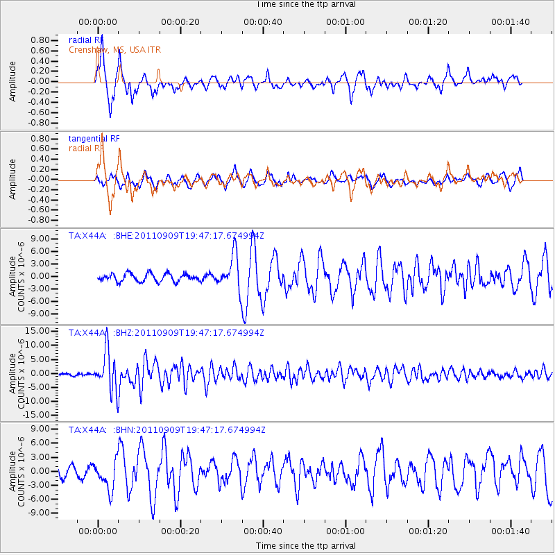
Earthquake location: Vancouver Island, Canada Region
Earthquake latitude/longitude: 49.5/-126.9
Earthquake time(UTC): 2011/09/09 (252) 19:41:34 GMT
Earthquake Depth: 22 km
Earthquake Magnitude: 6.3 MB, 6.4 MS, 6.4 MW, 6.5 MW
Earthquake Catalog/Contributor: WHDF/NEIC
Network: TA USArray Transportable Network (new EarthScope stations)
Station: X44A Crenshaw, MS, USA
Lat/Lon: 34.50 N/90.15 W
Elevation: 109 m
Distance: 30.8 deg
Az: 105.252 deg
Baz: 310.442 deg
Ray Param: 0.07921983
Estimated Moho Depth: 13.25 km
Estimated Crust Vp/Vs: 1.79
Assumed Crust Vp: 6.273 km/s
Estimated Crust Vs: 3.514 km/s
Estimated Crust Poisson's Ratio: 0.27
Radial Match: 89.2384 %
Radial Bump: 353
Transverse Match: 77.883865 %
Transverse Bump: 400
SOD ConfigId: 414626
Insert Time: 2012-01-20 13:00:58.603 +0000
GWidth: 2.5
Max Bumps: 400
Tol: 0.001

Signal To Noise

ChannelStoNSTALTA
TA:X44A: :BHZ:20110909T19:47:17.674994Z20.4255817.1931386E-63.5216323E-7
TA:X44A: :BHN:20110909T19:47:17.674994Z2.70445783.1775867E-61.1749441E-6
TA:X44A: :BHE:20110909T19:47:17.674994Z4.71926554.379707E-69.280485E-7
Arrivals
Ps1.8 SECOND
PpPs5.5 SECOND
PsPs/PpSs7.2 SECOND