You are here: Home > Network List > UW - Pacific Northwest Regional Seismic Network Stations List
> Station MRBL Marblemount, WA, USA > Earthquake Result Viewer
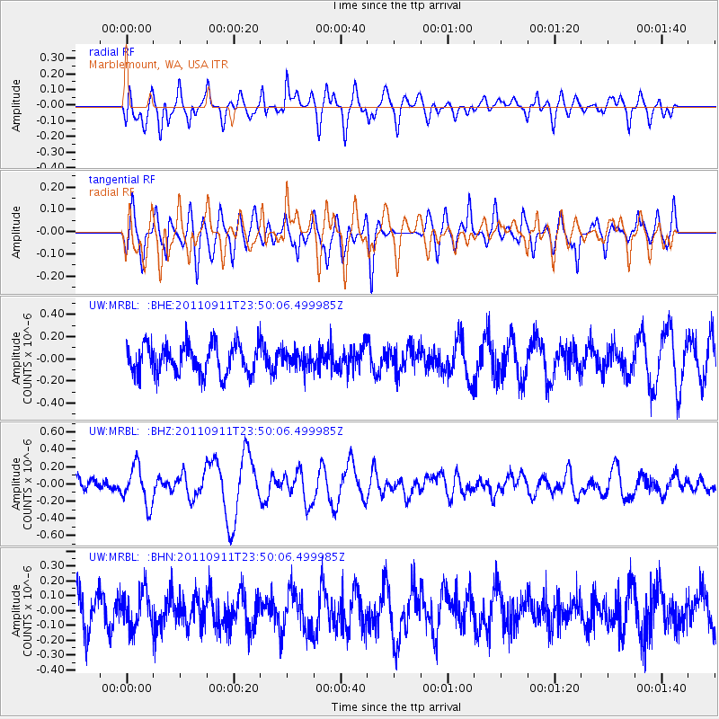
MRBL Marblemount, WA, USA - Earthquake Result Viewer
*The percent match for this event was below the threshold and hence no stack was calculated.
| Earthquake location: |
Vanuatu Islands |
| Earthquake latitude/longitude: |
-18.2/167.7 |
| Earthquake time(UTC): |
2011/09/11 (254) 23:37:34 GMT |
| Earthquake Depth: |
29 km |
| Earthquake Magnitude: |
5.5 MB, 5.7 MS, 5.7 MW, 5.8 MW |
| Earthquake Catalog/Contributor: |
WHDF/NEIC |
|
| Network: |
UW Pacific Northwest Regional Seismic Network |
| Station: |
MRBL Marblemount, WA, USA |
| Lat/Lon: |
48.52 N/121.48 W |
| Elevation: |
75 m |
|
| Distance: |
91.4 deg |
| Az: |
38.903 deg |
| Baz: |
243.887 deg |
| Ray Param: |
$rayparam |
*The percent match for this event was below the threshold and hence was not used in the summary stack. |
|
| Radial Match: |
49.778904 % |
| Radial Bump: |
400 |
| Transverse Match: |
63.284138 % |
| Transverse Bump: |
400 |
| SOD ConfigId: |
414626 |
| Insert Time: |
2012-01-23 09:17:24.929 +0000 |
| GWidth: |
2.5 |
| Max Bumps: |
400 |
| Tol: |
0.001 |
|
Signal To Noise
| Channel | StoN | STA | LTA |
| UW:MRBL: :BHZ:20110911T23:50:06.499985Z | 2.1185627 | 2.2543367E-7 | 1.0640878E-7 |
| UW:MRBL: :BHN:20110911T23:50:06.499985Z | 1.1096278 | 1.205225E-7 | 1.0861525E-7 |
| UW:MRBL: :BHE:20110911T23:50:06.499985Z | 0.54872 | 7.373011E-8 | 1.3436745E-7 |
| Arrivals |
| Ps | |
| PpPs | |
| PsPs/PpSs | |


