You are here: Home > Network List > TA - USArray Transportable Network (new EarthScope stations) Stations List
> Station C06D Leavenworth, WQ, USA > Earthquake Result Viewer
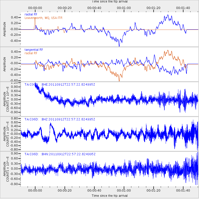
C06D Leavenworth, WQ, USA - Earthquake Result Viewer
*The percent match for this event was below the threshold and hence no stack was calculated.
| Earthquake location: |
Near N Coast Of New Guinea, P.N.G. |
| Earthquake latitude/longitude: |
-3.6/144.2 |
| Earthquake time(UTC): |
2011/09/12 (255) 22:44:28 GMT |
| Earthquake Depth: |
14 km |
| Earthquake Magnitude: |
5.8 MB, 5.7 MS, 6.0 MW, 6.0 MW |
| Earthquake Catalog/Contributor: |
WHDF/NEIC |
|
| Network: |
TA USArray Transportable Network (new EarthScope stations) |
| Station: |
C06D Leavenworth, WQ, USA |
| Lat/Lon: |
47.92 N/120.89 W |
| Elevation: |
544 m |
|
| Distance: |
96.0 deg |
| Az: |
42.36 deg |
| Baz: |
271.221 deg |
| Ray Param: |
$rayparam |
*The percent match for this event was below the threshold and hence was not used in the summary stack. |
|
| Radial Match: |
20.493792 % |
| Radial Bump: |
400 |
| Transverse Match: |
35.458065 % |
| Transverse Bump: |
400 |
| SOD ConfigId: |
414626 |
| Insert Time: |
2012-01-23 09:26:08.219 +0000 |
| GWidth: |
2.5 |
| Max Bumps: |
400 |
| Tol: |
0.001 |
|
Signal To Noise
| Channel | StoN | STA | LTA |
| TA:C06D: :BHZ:20110912T22:57:22.824995Z | 1.3546213 | 1.5638626E-7 | 1.1544648E-7 |
| TA:C06D: :BHN:20110912T22:57:22.824995Z | 0.9277856 | 1.7745135E-7 | 1.9126333E-7 |
| TA:C06D: :BHE:20110912T22:57:22.824995Z | 0.9692654 | 3.7170278E-7 | 3.8348915E-7 |
| Arrivals |
| Ps | |
| PpPs | |
| PsPs/PpSs | |


