You are here: Home > Network List > TA - USArray Transportable Network (new EarthScope stations) Stations List
> Station 234A Clairette, TX, USA > Earthquake Result Viewer
234A Clairette, TX, USA - Earthquake Result Viewer

| Earthquake location: |
Near Coast Of Central Chile |
| Earthquake latitude/longitude: |
-32.7/-71.8 |
| Earthquake time(UTC): |
2011/09/14 (257) 07:03:51 GMT |
| Earthquake Depth: |
37 km |
| Earthquake Magnitude: |
5.5 MS, 5.4 MB, 5.9 MW, 5.7 MW |
| Earthquake Catalog/Contributor: |
WHDF/NEIC |
|
| Network: |
TA USArray Transportable Network (new EarthScope stations) |
| Station: |
234A Clairette, TX, USA |
| Lat/Lon: |
32.00 N/98.14 W |
| Elevation: |
358 m |
|
| Distance: |
69.0 deg |
| Az: |
336.184 deg |
| Baz: |
156.375 deg |
| Ray Param: |
0.05587871 |
| Estimated Moho Depth: |
20.5 km |
| Estimated Crust Vp/Vs: |
2.05 |
| Assumed Crust Vp: |
6.426 km/s |
| Estimated Crust Vs: |
3.135 km/s |
| Estimated Crust Poisson's Ratio: |
0.34 |
|
| Radial Match: |
80.02217 % |
| Radial Bump: |
400 |
| Transverse Match: |
65.87848 % |
| Transverse Bump: |
394 |
| SOD ConfigId: |
414626 |
| Insert Time: |
2012-01-23 09:37:49.895 +0000 |
| GWidth: |
2.5 |
| Max Bumps: |
400 |
| Tol: |
0.001 |
|
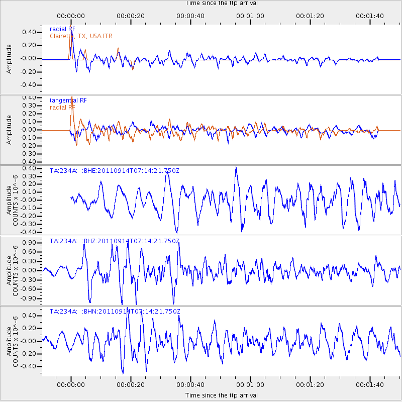
Signal To Noise
| Channel | StoN | STA | LTA |
| TA:234A: :BHZ:20110914T07:14:21.750Z | 2.7321086 | 3.2078862E-7 | 1.174143E-7 |
| TA:234A: :BHN:20110914T07:14:21.750Z | 1.2356278 | 1.04840296E-7 | 8.48478E-8 |
| TA:234A: :BHE:20110914T07:14:21.750Z | 1.9727747 | 2.1738597E-7 | 1.1019301E-7 |
| Arrivals |
| Ps | 3.5 SECOND |
| PpPs | 9.4 SECOND |
| PsPs/PpSs | 13 SECOND |


