You are here: Home > Network List > TA - USArray Transportable Network (new EarthScope stations) Stations List
> Station R36A Gordon, Harris, KS, USA > Earthquake Result Viewer
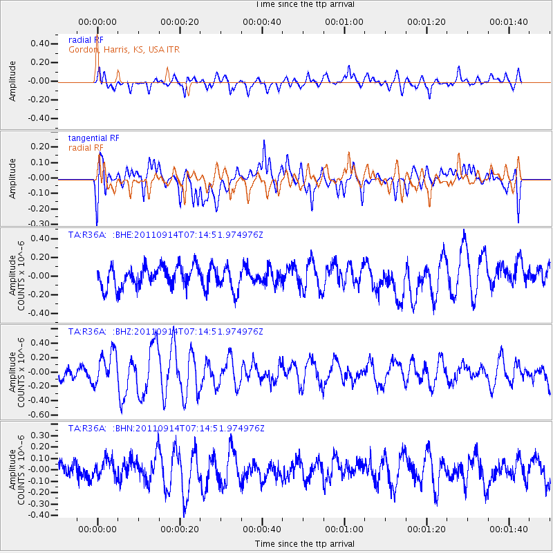
R36A Gordon, Harris, KS, USA - Earthquake Result Viewer
*The percent match for this event was below the threshold and hence no stack was calculated.
| Earthquake location: |
Near Coast Of Central Chile |
| Earthquake latitude/longitude: |
-32.7/-71.8 |
| Earthquake time(UTC): |
2011/09/14 (257) 07:03:51 GMT |
| Earthquake Depth: |
37 km |
| Earthquake Magnitude: |
5.5 MS, 5.4 MB, 5.9 MW, 5.7 MW |
| Earthquake Catalog/Contributor: |
WHDF/NEIC |
|
| Network: |
TA USArray Transportable Network (new EarthScope stations) |
| Station: |
R36A Gordon, Harris, KS, USA |
| Lat/Lon: |
38.32 N/95.50 W |
| Elevation: |
354 m |
|
| Distance: |
74.0 deg |
| Az: |
340.795 deg |
| Baz: |
159.352 deg |
| Ray Param: |
$rayparam |
*The percent match for this event was below the threshold and hence was not used in the summary stack. |
|
| Radial Match: |
63.27105 % |
| Radial Bump: |
400 |
| Transverse Match: |
55.732918 % |
| Transverse Bump: |
400 |
| SOD ConfigId: |
414626 |
| Insert Time: |
2012-01-23 09:38:37.878 +0000 |
| GWidth: |
2.5 |
| Max Bumps: |
400 |
| Tol: |
0.001 |
|
Signal To Noise
| Channel | StoN | STA | LTA |
| TA:R36A: :BHZ:20110914T07:14:51.974976Z | 1.9946666 | 2.3143967E-7 | 1.16029256E-7 |
| TA:R36A: :BHN:20110914T07:14:51.974976Z | 0.76727265 | 7.985244E-8 | 1.040731E-7 |
| TA:R36A: :BHE:20110914T07:14:51.974976Z | 1.2178496 | 1.3554369E-7 | 1.1129756E-7 |
| Arrivals |
| Ps | |
| PpPs | |
| PsPs/PpSs | |


