You are here: Home > Network List > TA - USArray Transportable Network (new EarthScope stations) Stations List
> Station X43A Marvell, AR, USA > Earthquake Result Viewer
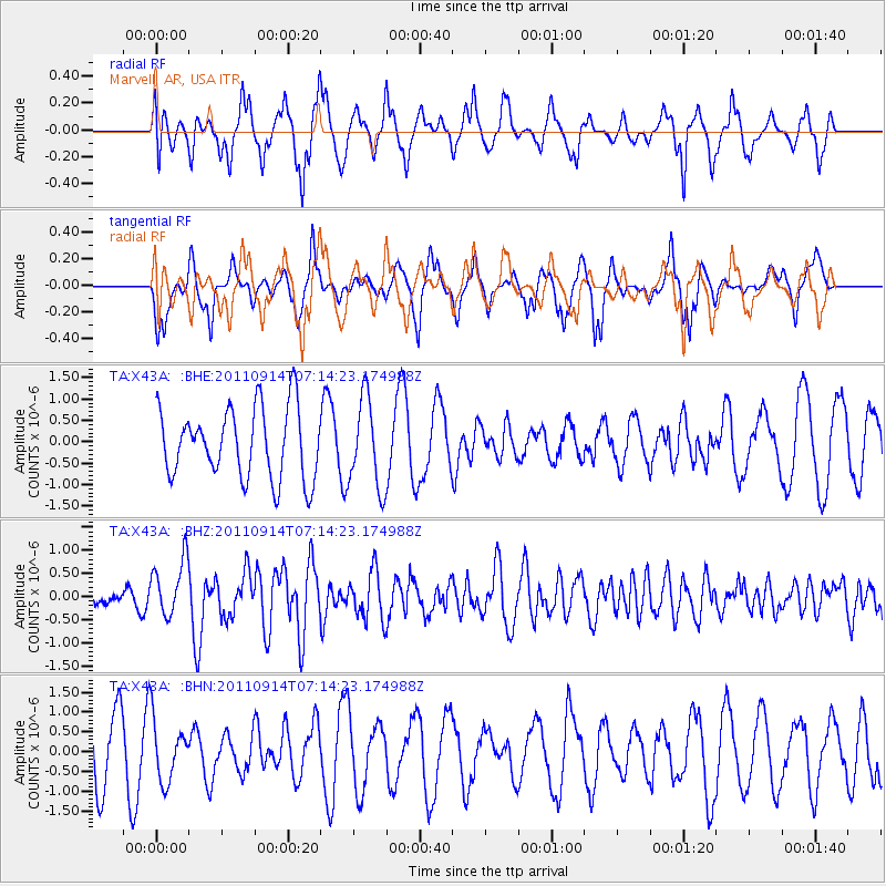
X43A Marvell, AR, USA - Earthquake Result Viewer
*The percent match for this event was below the threshold and hence no stack was calculated.
| Earthquake location: |
Near Coast Of Central Chile |
| Earthquake latitude/longitude: |
-32.7/-71.8 |
| Earthquake time(UTC): |
2011/09/14 (257) 07:03:51 GMT |
| Earthquake Depth: |
37 km |
| Earthquake Magnitude: |
5.5 MS, 5.4 MB, 5.9 MW, 5.7 MW |
| Earthquake Catalog/Contributor: |
WHDF/NEIC |
|
| Network: |
TA USArray Transportable Network (new EarthScope stations) |
| Station: |
X43A Marvell, AR, USA |
| Lat/Lon: |
34.52 N/90.88 W |
| Elevation: |
53 m |
|
| Distance: |
69.2 deg |
| Az: |
343.217 deg |
| Baz: |
162.851 deg |
| Ray Param: |
$rayparam |
*The percent match for this event was below the threshold and hence was not used in the summary stack. |
|
| Radial Match: |
52.662487 % |
| Radial Bump: |
348 |
| Transverse Match: |
61.547752 % |
| Transverse Bump: |
321 |
| SOD ConfigId: |
414626 |
| Insert Time: |
2012-01-23 09:47:05.901 +0000 |
| GWidth: |
2.5 |
| Max Bumps: |
400 |
| Tol: |
0.001 |
|
Signal To Noise
| Channel | StoN | STA | LTA |
| TA:X43A: :BHZ:20110914T07:14:23.174988Z | 2.5137267 | 6.0872816E-7 | 2.4216163E-7 |
| TA:X43A: :BHN:20110914T07:14:23.174988Z | 1.0874565 | 7.7349773E-7 | 7.112908E-7 |
| TA:X43A: :BHE:20110914T07:14:23.174988Z | 1.2725097 | 1.0419218E-6 | 8.1879284E-7 |
| Arrivals |
| Ps | |
| PpPs | |
| PsPs/PpSs | |


