You are here: Home > Network List > TA - USArray Transportable Network (new EarthScope stations) Stations List
> Station T44A Benton, MO, USA > Earthquake Result Viewer
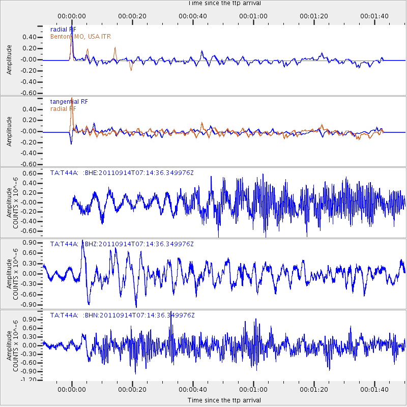
T44A Benton, MO, USA - Earthquake Result Viewer
*The percent match for this event was below the threshold and hence no stack was calculated.
| Earthquake location: |
Near Coast Of Central Chile |
| Earthquake latitude/longitude: |
-32.7/-71.8 |
| Earthquake time(UTC): |
2011/09/14 (257) 07:03:51 GMT |
| Earthquake Depth: |
37 km |
| Earthquake Magnitude: |
5.5 MS, 5.4 MB, 5.9 MW, 5.7 MW |
| Earthquake Catalog/Contributor: |
WHDF/NEIC |
|
| Network: |
TA USArray Transportable Network (new EarthScope stations) |
| Station: |
T44A Benton, MO, USA |
| Lat/Lon: |
37.09 N/89.59 W |
| Elevation: |
133 m |
|
| Distance: |
71.4 deg |
| Az: |
345.058 deg |
| Baz: |
164.224 deg |
| Ray Param: |
$rayparam |
*The percent match for this event was below the threshold and hence was not used in the summary stack. |
|
| Radial Match: |
70.547615 % |
| Radial Bump: |
400 |
| Transverse Match: |
49.834568 % |
| Transverse Bump: |
400 |
| SOD ConfigId: |
414626 |
| Insert Time: |
2012-01-23 09:48:28.448 +0000 |
| GWidth: |
2.5 |
| Max Bumps: |
400 |
| Tol: |
0.001 |
|
Signal To Noise
| Channel | StoN | STA | LTA |
| TA:T44A: :BHZ:20110914T07:14:36.349976Z | 2.4749112 | 3.7504194E-7 | 1.5153753E-7 |
| TA:T44A: :BHN:20110914T07:14:36.349976Z | 1.3117107 | 1.8738876E-7 | 1.428583E-7 |
| TA:T44A: :BHE:20110914T07:14:36.349976Z | 1.1769947 | 1.6189188E-7 | 1.375468E-7 |
| Arrivals |
| Ps | |
| PpPs | |
| PsPs/PpSs | |


