You are here: Home > Network List > TA - USArray Transportable Network (new EarthScope stations) Stations List
> Station Y12C Blythe, CA, USA > Earthquake Result Viewer
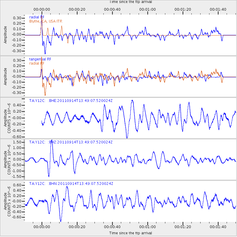
Y12C Blythe, CA, USA - Earthquake Result Viewer
*The percent match for this event was below the threshold and hence no stack was calculated.
| Earthquake location: |
East Of North Island, N.Z. |
| Earthquake latitude/longitude: |
-35.1/-179.0 |
| Earthquake time(UTC): |
2011/09/14 (257) 13:36:34 GMT |
| Earthquake Depth: |
13 km |
| Earthquake Magnitude: |
5.6 MB, 5.6 MS, 5.7 MW |
| Earthquake Catalog/Contributor: |
WHDF/NEIC |
|
| Network: |
TA USArray Transportable Network (new EarthScope stations) |
| Station: |
Y12C Blythe, CA, USA |
| Lat/Lon: |
33.75 N/114.52 W |
| Elevation: |
196 m |
|
| Distance: |
91.3 deg |
| Az: |
48.764 deg |
| Baz: |
227.728 deg |
| Ray Param: |
$rayparam |
*The percent match for this event was below the threshold and hence was not used in the summary stack. |
|
| Radial Match: |
55.722233 % |
| Radial Bump: |
400 |
| Transverse Match: |
65.97867 % |
| Transverse Bump: |
400 |
| SOD ConfigId: |
414626 |
| Insert Time: |
2012-01-23 10:04:16.620 +0000 |
| GWidth: |
2.5 |
| Max Bumps: |
400 |
| Tol: |
0.001 |
|
Signal To Noise
| Channel | StoN | STA | LTA |
| TA:Y12C: :BHZ:20110914T13:49:07.520024Z | 3.8264313 | 5.359782E-7 | 1.400726E-7 |
| TA:Y12C: :BHN:20110914T13:49:07.520024Z | 1.341725 | 1.8395473E-7 | 1.3710316E-7 |
| TA:Y12C: :BHE:20110914T13:49:07.520024Z | 1.5932764 | 1.7147354E-7 | 1.0762322E-7 |
| Arrivals |
| Ps | |
| PpPs | |
| PsPs/PpSs | |


