You are here: Home > Network List > TA - USArray Transportable Network (new EarthScope stations) Stations List
> Station Z41A Richland Creek Farm, El Dorado, AR, USA > Earthquake Result Viewer
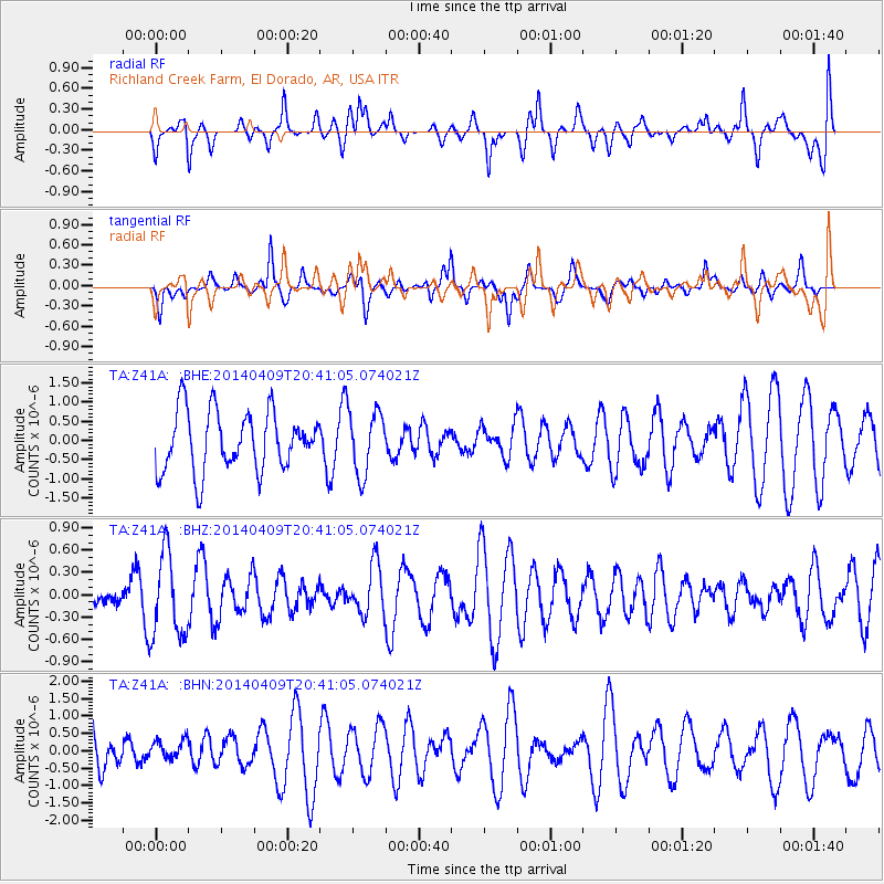
Z41A Richland Creek Farm, El Dorado, AR, USA - Earthquake Result Viewer
*The percent match for this event was below the threshold and hence no stack was calculated.
| Earthquake location: |
Fiji Islands Region |
| Earthquake latitude/longitude: |
-14.7/-176.0 |
| Earthquake time(UTC): |
2014/04/09 (099) 20:29:02 GMT |
| Earthquake Depth: |
327 km |
| Earthquake Magnitude: |
5.5 MW |
| Earthquake Catalog/Contributor: |
ISC/ISC |
|
| Network: |
TA USArray Transportable Network (new EarthScope stations) |
| Station: |
Z41A Richland Creek Farm, El Dorado, AR, USA |
| Lat/Lon: |
33.26 N/92.80 W |
| Elevation: |
62 m |
|
| Distance: |
92.4 deg |
| Az: |
56.387 deg |
| Baz: |
254.123 deg |
| Ray Param: |
$rayparam |
*The percent match for this event was below the threshold and hence was not used in the summary stack. |
|
| Radial Match: |
62.061123 % |
| Radial Bump: |
400 |
| Transverse Match: |
63.243927 % |
| Transverse Bump: |
338 |
| SOD ConfigId: |
3390531 |
| Insert Time: |
2019-04-11 06:02:40.776 +0000 |
| GWidth: |
2.5 |
| Max Bumps: |
400 |
| Tol: |
0.001 |
|
Signal To Noise
| Channel | StoN | STA | LTA |
| TA:Z41A: :BHZ:20140409T20:41:05.074021Z | 2.979482 | 5.650623E-7 | 1.896512E-7 |
| TA:Z41A: :BHN:20140409T20:41:05.074021Z | 0.7002204 | 2.96721E-7 | 4.2375373E-7 |
| TA:Z41A: :BHE:20140409T20:41:05.074021Z | 1.083274 | 8.354163E-7 | 7.7119574E-7 |
| Arrivals |
| Ps | |
| PpPs | |
| PsPs/PpSs | |


