You are here: Home > Network List > TA - USArray Transportable Network (new EarthScope stations) Stations List
> Station L02D Cave Junction, OR, USA > Earthquake Result Viewer
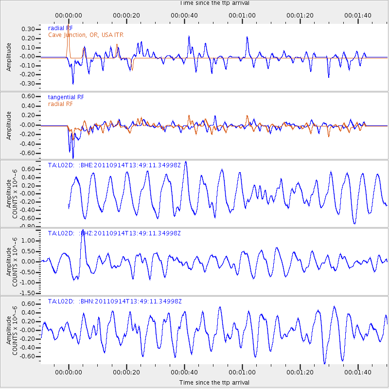
L02D Cave Junction, OR, USA - Earthquake Result Viewer
*The percent match for this event was below the threshold and hence no stack was calculated.
| Earthquake location: |
East Of North Island, N.Z. |
| Earthquake latitude/longitude: |
-35.1/-179.0 |
| Earthquake time(UTC): |
2011/09/14 (257) 13:36:34 GMT |
| Earthquake Depth: |
13 km |
| Earthquake Magnitude: |
5.6 MB, 5.6 MS, 5.7 MW |
| Earthquake Catalog/Contributor: |
WHDF/NEIC |
|
| Network: |
TA USArray Transportable Network (new EarthScope stations) |
| Station: |
L02D Cave Junction, OR, USA |
| Lat/Lon: |
42.16 N/123.60 W |
| Elevation: |
458 m |
|
| Distance: |
92.1 deg |
| Az: |
37.76 deg |
| Baz: |
222.47 deg |
| Ray Param: |
$rayparam |
*The percent match for this event was below the threshold and hence was not used in the summary stack. |
|
| Radial Match: |
69.00375 % |
| Radial Bump: |
361 |
| Transverse Match: |
64.21623 % |
| Transverse Bump: |
400 |
| SOD ConfigId: |
414626 |
| Insert Time: |
2012-01-23 10:05:21.207 +0000 |
| GWidth: |
2.5 |
| Max Bumps: |
400 |
| Tol: |
0.001 |
|
Signal To Noise
| Channel | StoN | STA | LTA |
| TA:L02D: :BHZ:20110914T13:49:11.34998Z | 3.4598298 | 6.7275204E-7 | 1.9444657E-7 |
| TA:L02D: :BHN:20110914T13:49:11.34998Z | 1.0464841 | 1.6465656E-7 | 1.5734263E-7 |
| TA:L02D: :BHE:20110914T13:49:11.34998Z | 1.1780919 | 3.8599623E-7 | 3.2764527E-7 |
| Arrivals |
| Ps | |
| PpPs | |
| PsPs/PpSs | |


