You are here: Home > Network List > UW - Pacific Northwest Regional Seismic Network Stations List
> Station WOLL Wollman Farm, Schrag, WA, USA > Earthquake Result Viewer
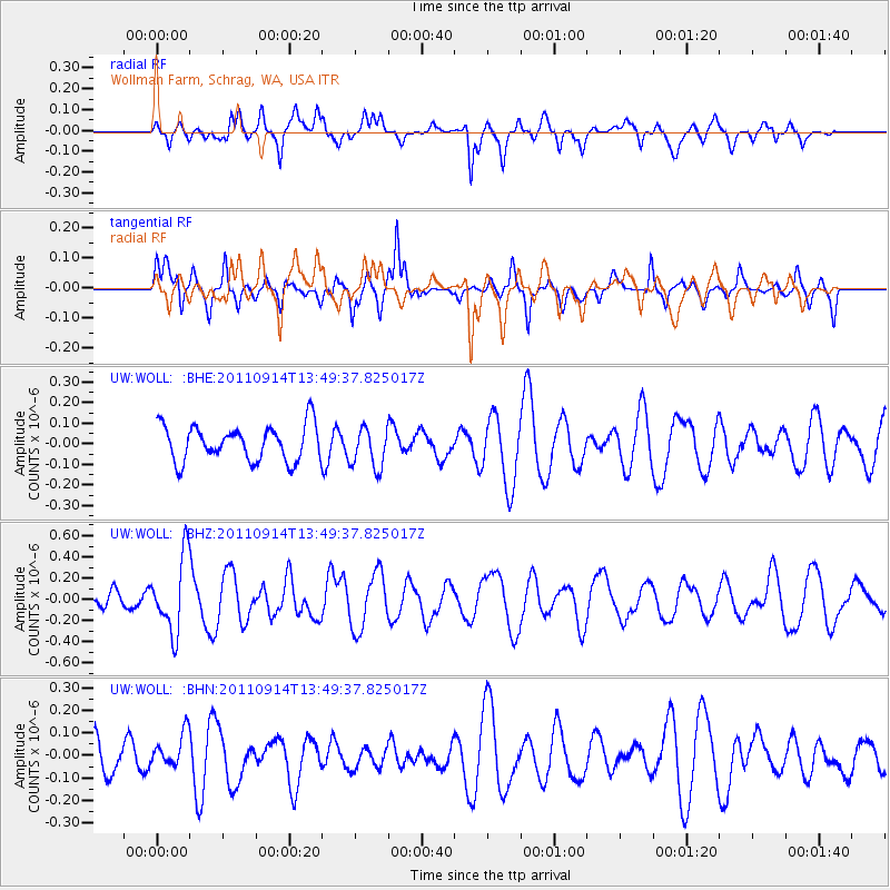
WOLL Wollman Farm, Schrag, WA, USA - Earthquake Result Viewer
*The percent match for this event was below the threshold and hence no stack was calculated.
| Earthquake location: |
East Of North Island, N.Z. |
| Earthquake latitude/longitude: |
-35.1/-179.0 |
| Earthquake time(UTC): |
2011/09/14 (257) 13:36:34 GMT |
| Earthquake Depth: |
13 km |
| Earthquake Magnitude: |
5.6 MB, 5.6 MS, 5.7 MW |
| Earthquake Catalog/Contributor: |
WHDF/NEIC |
|
| Network: |
UW Pacific Northwest Regional Seismic Network |
| Station: |
WOLL Wollman Farm, Schrag, WA, USA |
| Lat/Lon: |
47.06 N/118.92 W |
| Elevation: |
385 m |
|
| Distance: |
97.9 deg |
| Az: |
36.746 deg |
| Baz: |
225.84 deg |
| Ray Param: |
$rayparam |
*The percent match for this event was below the threshold and hence was not used in the summary stack. |
|
| Radial Match: |
60.230762 % |
| Radial Bump: |
400 |
| Transverse Match: |
40.71406 % |
| Transverse Bump: |
328 |
| SOD ConfigId: |
414626 |
| Insert Time: |
2012-01-23 10:07:06.144 +0000 |
| GWidth: |
2.5 |
| Max Bumps: |
400 |
| Tol: |
0.001 |
|
Signal To Noise
| Channel | StoN | STA | LTA |
| UW:WOLL: :BHZ:20110914T13:49:37.825017Z | 4.103235 | 3.5013107E-7 | 8.53305E-8 |
| UW:WOLL: :BHN:20110914T13:49:37.825017Z | 0.7420434 | 7.664476E-8 | 1.03288784E-7 |
| UW:WOLL: :BHE:20110914T13:49:37.825017Z | 1.1553293 | 9.902908E-8 | 8.571502E-8 |
| Arrivals |
| Ps | |
| PpPs | |
| PsPs/PpSs | |


