You are here: Home > Network List > CI - Caltech Regional Seismic Network Stations List
> Station SHO Shoshone, CA, USA > Earthquake Result Viewer
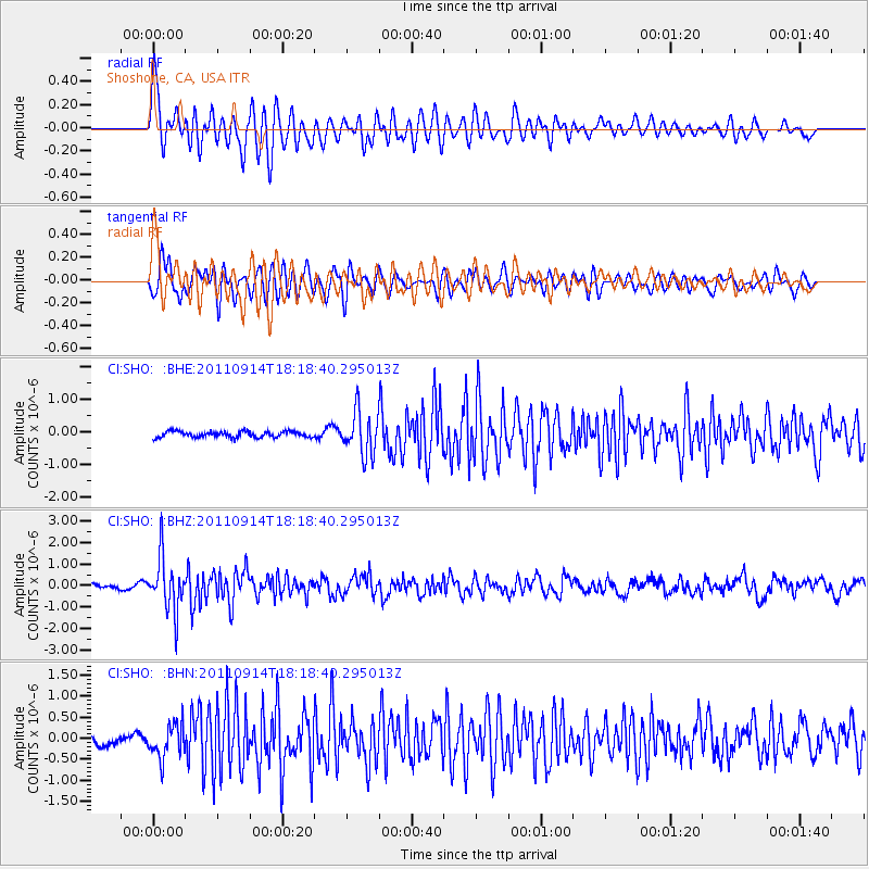
SHO Shoshone, CA, USA - Earthquake Result Viewer
*The percent match for this event was below the threshold and hence no stack was calculated.
| Earthquake location: |
Near Islands, Aleutian Islands |
| Earthquake latitude/longitude: |
53.1/173.0 |
| Earthquake time(UTC): |
2011/09/14 (257) 18:10:09 GMT |
| Earthquake Depth: |
15 km |
| Earthquake Magnitude: |
6.1 MB, 5.7 MS, 6.0 MW, 6.0 MW |
| Earthquake Catalog/Contributor: |
WHDF/NEIC |
|
| Network: |
CI Caltech Regional Seismic Network |
| Station: |
SHO Shoshone, CA, USA |
| Lat/Lon: |
35.90 N/116.28 W |
| Elevation: |
451 m |
|
| Distance: |
51.2 deg |
| Az: |
79.771 deg |
| Baz: |
313.049 deg |
| Ray Param: |
$rayparam |
*The percent match for this event was below the threshold and hence was not used in the summary stack. |
|
| Radial Match: |
76.967926 % |
| Radial Bump: |
400 |
| Transverse Match: |
81.21395 % |
| Transverse Bump: |
400 |
| SOD ConfigId: |
414626 |
| Insert Time: |
2012-01-23 10:15:15.382 +0000 |
| GWidth: |
2.5 |
| Max Bumps: |
400 |
| Tol: |
0.001 |
|
Signal To Noise
| Channel | StoN | STA | LTA |
| CI:SHO: :BHZ:20110914T18:18:40.295013Z | 9.319961 | 1.2446948E-6 | 1.3355151E-7 |
| CI:SHO: :BHN:20110914T18:18:40.295013Z | 2.8961077 | 3.9966022E-7 | 1.379991E-7 |
| CI:SHO: :BHE:20110914T18:18:40.295013Z | 7.4948363 | 6.6512683E-7 | 8.8744684E-8 |
| Arrivals |
| Ps | |
| PpPs | |
| PsPs/PpSs | |


