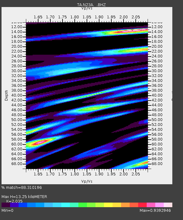
N23A Red Feather Lakes, CO, USA - Earthquake Result Viewer
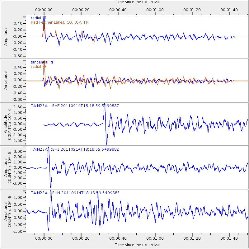
Earthquake location: Near Islands, Aleutian Islands
Earthquake latitude/longitude: 53.1/173.0
Earthquake time(UTC): 2011/09/14 (257) 18:10:09 GMT
Earthquake Depth: 15 km
Earthquake Magnitude: 6.1 MB, 5.7 MS, 6.0 MW, 6.0 MW
Earthquake Catalog/Contributor: WHDF/NEIC
Network: TA USArray Transportable Network (new EarthScope stations)
Station: N23A Red Feather Lakes, CO, USA
Lat/Lon: 40.89 N/105.94 W
Elevation: 2458 m
Distance: 53.8 deg
Az: 68.214 deg
Baz: 312.397 deg
Ray Param: 0.065874554
Estimated Moho Depth: 13.25 km
Estimated Crust Vp/Vs: 2.04
Assumed Crust Vp: 6.306 km/s
Estimated Crust Vs: 3.099 km/s
Estimated Crust Poisson's Ratio: 0.34
Radial Match: 88.310196 %
Radial Bump: 400
Transverse Match: 79.34714 %
Transverse Bump: 400
SOD ConfigId: 414626
Insert Time: 2012-01-23 10:28:56.000 +0000
GWidth: 2.5
Max Bumps: 400
Tol: 0.001

Signal To Noise

ChannelStoNSTALTA
TA:N23A: :BHZ:20110914T18:18:59.549988Z27.5410881.8562356E-66.739877E-8
TA:N23A: :BHN:20110914T18:18:59.549988Z7.93074277.105509E-78.9594494E-8
TA:N23A: :BHE:20110914T18:18:59.549988Z9.91258058.503566E-78.5785594E-8
Arrivals
Ps2.3 SECOND
PpPs6.1 SECOND
PsPs/PpSs8.4 SECOND