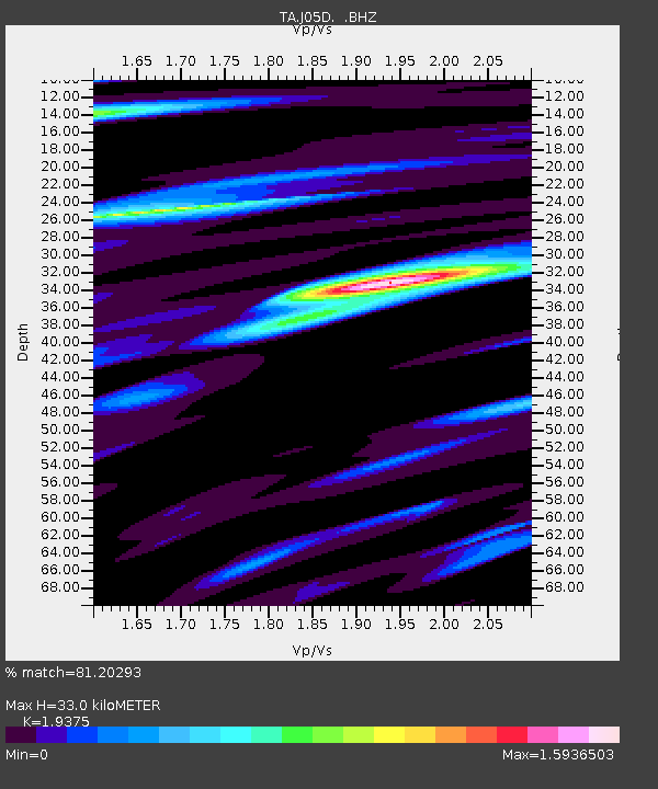
J05D Fort Rock, OR, USA - Earthquake Result Viewer

Earthquake location: Near Islands, Aleutian Islands
Earthquake latitude/longitude: 53.1/173.0
Earthquake time(UTC): 2011/09/14 (257) 18:10:09 GMT
Earthquake Depth: 15 km
Earthquake Magnitude: 6.1 MB, 5.7 MS, 6.0 MW, 6.0 MW
Earthquake Catalog/Contributor: WHDF/NEIC
Network: TA USArray Transportable Network (new EarthScope stations)
Station: J05D Fort Rock, OR, USA
Lat/Lon: 43.28 N/121.23 W
Elevation: 1541 m
Distance: 43.5 deg
Az: 75.447 deg
Baz: 306.954 deg
Ray Param: 0.07251451
Estimated Moho Depth: 33.0 km
Estimated Crust Vp/Vs: 1.94
Assumed Crust Vp: 6.597 km/s
Estimated Crust Vs: 3.405 km/s
Estimated Crust Poisson's Ratio: 0.32
Radial Match: 81.20293 %
Radial Bump: 400
Transverse Match: 71.6801 %
Transverse Bump: 400
SOD ConfigId: 414626
Insert Time: 2012-01-23 10:30:13.658 +0000
GWidth: 2.5
Max Bumps: 400
Tol: 0.001

Signal To Noise

ChannelStoNSTALTA
TA:J05D: :BHZ:20110914T18:17:40.600006Z20.0464172.805723E-61.3996132E-7
TA:J05D: :BHN:20110914T18:17:40.600006Z3.17803039.4083873E-72.9604462E-7
TA:J05D: :BHE:20110914T18:17:40.600006Z6.39951851.4583355E-62.2788208E-7
Arrivals
Ps5.0 SECOND
PpPs14 SECOND
PsPs/PpSs19 SECOND