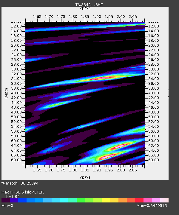
334A Lometa, TX, USA - Earthquake Result Viewer
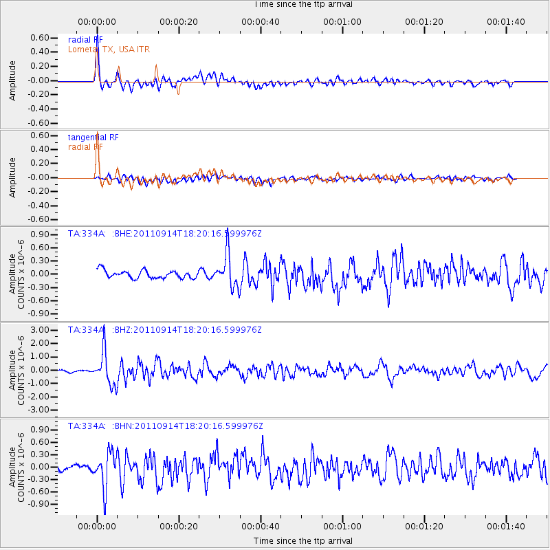
Earthquake location: Near Islands, Aleutian Islands
Earthquake latitude/longitude: 53.1/173.0
Earthquake time(UTC): 2011/09/14 (257) 18:10:09 GMT
Earthquake Depth: 15 km
Earthquake Magnitude: 6.1 MB, 5.7 MS, 6.0 MW, 6.0 MW
Earthquake Catalog/Contributor: WHDF/NEIC
Network: TA USArray Transportable Network (new EarthScope stations)
Station: 334A Lometa, TX, USA
Lat/Lon: 31.33 N/98.24 W
Elevation: 389 m
Distance: 64.9 deg
Az: 70.83 deg
Baz: 318.28 deg
Ray Param: 0.058599435
Estimated Moho Depth: 66.5 km
Estimated Crust Vp/Vs: 1.94
Assumed Crust Vp: 6.498 km/s
Estimated Crust Vs: 3.349 km/s
Estimated Crust Poisson's Ratio: 0.32
Radial Match: 86.25394 %
Radial Bump: 400
Transverse Match: 68.71256 %
Transverse Bump: 400
SOD ConfigId: 414626
Insert Time: 2012-01-23 10:31:24.354 +0000
GWidth: 2.5
Max Bumps: 400
Tol: 0.001

Signal To Noise

ChannelStoNSTALTA
TA:334A: :BHZ:20110914T18:20:16.599976Z14.9041851.2721141E-68.535281E-8
TA:334A: :BHN:20110914T18:20:16.599976Z6.1696294.330183E-77.0185465E-8
TA:334A: :BHE:20110914T18:20:16.599976Z4.47023533.9562914E-78.850298E-8
Arrivals
Ps10 SECOND
PpPs29 SECOND
PsPs/PpSs39 SECOND