You are here: Home > Network List > TA - USArray Transportable Network (new EarthScope stations) Stations List
> Station 733A Divot King Ranch, Dilley, TX, USA > Earthquake Result Viewer
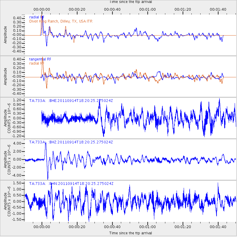
733A Divot King Ranch, Dilley, TX, USA - Earthquake Result Viewer

| Earthquake location: |
Near Islands, Aleutian Islands |
| Earthquake latitude/longitude: |
53.1/173.0 |
| Earthquake time(UTC): |
2011/09/14 (257) 18:10:09 GMT |
| Earthquake Depth: |
15 km |
| Earthquake Magnitude: |
6.1 MB, 5.7 MS, 6.0 MW, 6.0 MW |
| Earthquake Catalog/Contributor: |
WHDF/NEIC |
|
| Network: |
TA USArray Transportable Network (new EarthScope stations) |
| Station: |
733A Divot King Ranch, Dilley, TX, USA |
| Lat/Lon: |
28.72 N/99.29 W |
| Elevation: |
169 m |
|
| Distance: |
66.3 deg |
| Az: |
73.477 deg |
| Baz: |
318.848 deg |
| Ray Param: |
0.05771607 |
| Estimated Moho Depth: |
31.75 km |
| Estimated Crust Vp/Vs: |
1.82 |
| Assumed Crust Vp: |
6.347 km/s |
| Estimated Crust Vs: |
3.492 km/s |
| Estimated Crust Poisson's Ratio: |
0.28 |
|
| Radial Match: |
81.89947 % |
| Radial Bump: |
400 |
| Transverse Match: |
74.37413 % |
| Transverse Bump: |
400 |
| SOD ConfigId: |
414626 |
| Insert Time: |
2012-01-23 10:32:01.359 +0000 |
| GWidth: |
2.5 |
| Max Bumps: |
400 |
| Tol: |
0.001 |
|
Signal To Noise
| Channel | StoN | STA | LTA |
| TA:733A: :BHZ:20110914T18:20:25.275024Z | 11.569676 | 1.9432414E-6 | 1.6795985E-7 |
| TA:733A: :BHN:20110914T18:20:25.275024Z | 1.8381557 | 5.2799743E-7 | 2.87243E-7 |
| TA:733A: :BHE:20110914T18:20:25.275024Z | 2.918185 | 5.0096725E-7 | 1.7167083E-7 |
| Arrivals |
| Ps | 4.3 SECOND |
| PpPs | 14 SECOND |
| PsPs/PpSs | 18 SECOND |


