You are here: Home > Network List > TA - USArray Transportable Network (new EarthScope stations) Stations List
> Station 633A Saathoff Ranch, Hondo, TX, USA > Earthquake Result Viewer
633A Saathoff Ranch, Hondo, TX, USA - Earthquake Result Viewer
| Earthquake location: |
Near Islands, Aleutian Islands |
| Earthquake latitude/longitude: |
53.1/173.0 |
| Earthquake time(UTC): |
2011/09/14 (257) 18:10:09 GMT |
| Earthquake Depth: |
15 km |
| Earthquake Magnitude: |
6.1 MB, 5.7 MS, 6.0 MW, 6.0 MW |
| Earthquake Catalog/Contributor: |
WHDF/NEIC |
|
| Network: |
TA USArray Transportable Network (new EarthScope stations) |
| Station: |
633A Saathoff Ranch, Hondo, TX, USA |
| Lat/Lon: |
29.46 N/99.18 W |
| Elevation: |
320 m |
|
| Distance: |
65.8 deg |
| Az: |
72.86 deg |
| Baz: |
318.654 deg |
| Ray Param: |
0.058034718 |
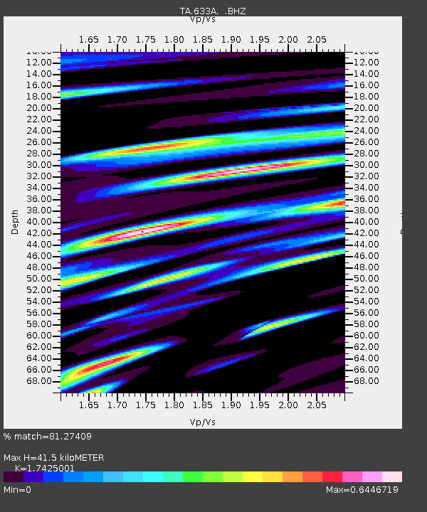
| Estimated Moho Depth: |
41.5 km |
| Estimated Crust Vp/Vs: |
1.74 |
| Assumed Crust Vp: |
6.347 km/s |
| Estimated Crust Vs: |
3.643 km/s |
| Estimated Crust Poisson's Ratio: |
0.25 |
|
| Radial Match: |
81.27409 % |
| Radial Bump: |
400 |
| Transverse Match: |
64.923225 % |
| Transverse Bump: |
400 |
| SOD ConfigId: |
414626 |
| Insert Time: |
2012-01-23 10:32:05.829 +0000 |
| GWidth: |
2.5 |
| Max Bumps: |
400 |
| Tol: |
0.001 |
|
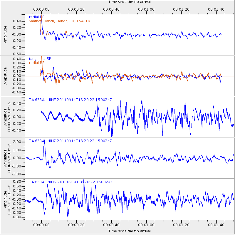
Signal To Noise
| Channel | StoN | STA | LTA |
| TA:633A: :BHZ:20110914T18:20:22.150024Z | 9.640356 | 9.036684E-7 | 9.373807E-8 |
| TA:633A: :BHN:20110914T18:20:22.150024Z | 4.397994 | 3.5715072E-7 | 8.1207645E-8 |
| TA:633A: :BHE:20110914T18:20:22.150024Z | 3.092997 | 2.42566E-7 | 7.842426E-8 |
| Arrivals |
| Ps | 5.1 SECOND |
| PpPs | 17 SECOND |
| PsPs/PpSs | 22 SECOND |


