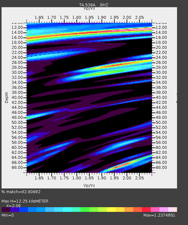
536A Bastrop, TX, USA - Earthquake Result Viewer

Earthquake location: Near Islands, Aleutian Islands
Earthquake latitude/longitude: 53.1/173.0
Earthquake time(UTC): 2011/09/14 (257) 18:10:09 GMT
Earthquake Depth: 15 km
Earthquake Magnitude: 6.1 MB, 5.7 MS, 6.0 MW, 6.0 MW
Earthquake Catalog/Contributor: WHDF/NEIC
Network: TA USArray Transportable Network (new EarthScope stations)
Station: 536A Bastrop, TX, USA
Lat/Lon: 30.08 N/97.07 W
Elevation: 115 m
Distance: 66.5 deg
Az: 70.908 deg
Baz: 318.908 deg
Ray Param: 0.057544705
Estimated Moho Depth: 12.25 km
Estimated Crust Vp/Vs: 2.09
Assumed Crust Vp: 6.347 km/s
Estimated Crust Vs: 3.037 km/s
Estimated Crust Poisson's Ratio: 0.35
Radial Match: 82.80692 %
Radial Bump: 400
Transverse Match: 65.40312 %
Transverse Bump: 400
SOD ConfigId: 414626
Insert Time: 2012-01-23 10:33:16.084 +0000
GWidth: 2.5
Max Bumps: 400
Tol: 0.001

Signal To Noise

ChannelStoNSTALTA
TA:536A: :BHZ:20110914T18:20:26.924988Z11.5458831.6283519E-61.4103313E-7
TA:536A: :BHN:20110914T18:20:26.924988Z2.36231285.841805E-72.4729175E-7
TA:536A: :BHE:20110914T18:20:26.924988Z1.4686093.8077266E-72.5927437E-7
Arrivals
Ps2.2 SECOND
PpPs5.8 SECOND
PsPs/PpSs7.9 SECOND