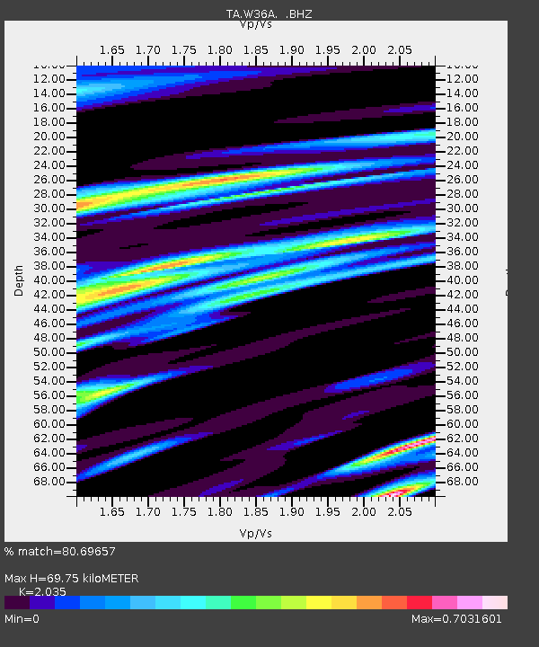
W36A Wetumka, OK, USA - Earthquake Result Viewer
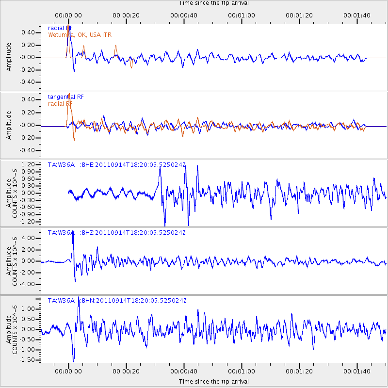
Earthquake location: Near Islands, Aleutian Islands
Earthquake latitude/longitude: 53.1/173.0
Earthquake time(UTC): 2011/09/14 (257) 18:10:09 GMT
Earthquake Depth: 15 km
Earthquake Magnitude: 6.1 MB, 5.7 MS, 6.0 MW, 6.0 MW
Earthquake Catalog/Contributor: WHDF/NEIC
Network: TA USArray Transportable Network (new EarthScope stations)
Station: W36A Wetumka, OK, USA
Lat/Lon: 35.14 N/96.23 W
Elevation: 251 m
Distance: 63.2 deg
Az: 66.61 deg
Baz: 317.532 deg
Ray Param: 0.059697326
Estimated Moho Depth: 69.75 km
Estimated Crust Vp/Vs: 2.04
Assumed Crust Vp: 6.426 km/s
Estimated Crust Vs: 3.158 km/s
Estimated Crust Poisson's Ratio: 0.34
Radial Match: 80.69657 %
Radial Bump: 400
Transverse Match: 70.11836 %
Transverse Bump: 400
SOD ConfigId: 414626
Insert Time: 2012-01-23 10:35:49.308 +0000
GWidth: 2.5
Max Bumps: 400
Tol: 0.001

Signal To Noise

ChannelStoNSTALTA
TA:W36A: :BHZ:20110914T18:20:05.525024Z19.910791.8734987E-69.409465E-8
TA:W36A: :BHN:20110914T18:20:05.525024Z4.91601667.234867E-71.471693E-7
TA:W36A: :BHE:20110914T18:20:05.525024Z4.5775435.6561714E-71.2356348E-7
Arrivals
Ps12 SECOND
PpPs32 SECOND
PsPs/PpSs43 SECOND