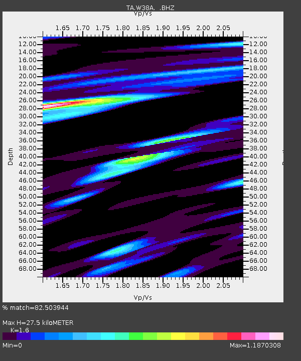
W38A Poteau, OK, USA - Earthquake Result Viewer
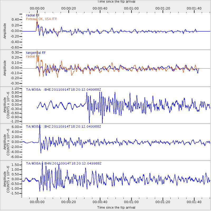
Earthquake location: Near Islands, Aleutian Islands
Earthquake latitude/longitude: 53.1/173.0
Earthquake time(UTC): 2011/09/14 (257) 18:10:09 GMT
Earthquake Depth: 15 km
Earthquake Magnitude: 6.1 MB, 5.7 MS, 6.0 MW, 6.0 MW
Earthquake Catalog/Contributor: WHDF/NEIC
Network: TA USArray Transportable Network (new EarthScope stations)
Station: W38A Poteau, OK, USA
Lat/Lon: 35.07 N/94.52 W
Elevation: 169 m
Distance: 64.2 deg
Az: 65.505 deg
Baz: 318.021 deg
Ray Param: 0.059046436
Estimated Moho Depth: 27.5 km
Estimated Crust Vp/Vs: 1.60
Assumed Crust Vp: 6.498 km/s
Estimated Crust Vs: 4.061 km/s
Estimated Crust Poisson's Ratio: 0.18
Radial Match: 82.503944 %
Radial Bump: 400
Transverse Match: 63.028076 %
Transverse Bump: 400
SOD ConfigId: 414626
Insert Time: 2012-01-23 10:36:19.015 +0000
GWidth: 2.5
Max Bumps: 400
Tol: 0.001

Signal To Noise

ChannelStoNSTALTA
TA:W38A: :BHZ:20110914T18:20:12.049988Z14.2041052.2994984E-61.618897E-7
TA:W38A: :BHN:20110914T18:20:12.049988Z5.37446986.661915E-71.2395485E-7
TA:W38A: :BHE:20110914T18:20:12.049988Z2.95725084.7093744E-71.5924839E-7
Arrivals
Ps2.7 SECOND
PpPs10 SECOND
PsPs/PpSs13 SECOND