You are here: Home > Network List > TA - USArray Transportable Network (new EarthScope stations) Stations List
> Station 236A Katherine and Luke Keathley, Corsicana, TX, USA > Earthquake Result Viewer
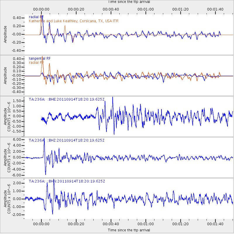
236A Katherine and Luke Keathley, Corsicana, TX, USA - Earthquake Result Viewer

| Earthquake location: |
Near Islands, Aleutian Islands |
| Earthquake latitude/longitude: |
53.1/173.0 |
| Earthquake time(UTC): |
2011/09/14 (257) 18:10:09 GMT |
| Earthquake Depth: |
15 km |
| Earthquake Magnitude: |
6.1 MB, 5.7 MS, 6.0 MW, 6.0 MW |
| Earthquake Catalog/Contributor: |
WHDF/NEIC |
|
| Network: |
TA USArray Transportable Network (new EarthScope stations) |
| Station: |
236A Katherine and Luke Keathley, Corsicana, TX, USA |
| Lat/Lon: |
32.00 N/96.53 W |
| Elevation: |
118 m |
|
| Distance: |
65.4 deg |
| Az: |
69.144 deg |
| Baz: |
318.463 deg |
| Ray Param: |
0.058290996 |
| Estimated Moho Depth: |
36.0 km |
| Estimated Crust Vp/Vs: |
1.80 |
| Assumed Crust Vp: |
6.347 km/s |
| Estimated Crust Vs: |
3.526 km/s |
| Estimated Crust Poisson's Ratio: |
0.28 |
|
| Radial Match: |
90.95189 % |
| Radial Bump: |
400 |
| Transverse Match: |
75.06782 % |
| Transverse Bump: |
400 |
| SOD ConfigId: |
414626 |
| Insert Time: |
2012-01-23 10:36:43.599 +0000 |
| GWidth: |
2.5 |
| Max Bumps: |
400 |
| Tol: |
0.001 |
|
Signal To Noise
| Channel | StoN | STA | LTA |
| TA:236A: :BHZ:20110914T18:20:19.625Z | 20.337923 | 2.3649022E-6 | 1.1628042E-7 |
| TA:236A: :BHN:20110914T18:20:19.625Z | 5.183769 | 7.9789544E-7 | 1.5392187E-7 |
| TA:236A: :BHE:20110914T18:20:19.625Z | 2.2455363 | 5.111685E-7 | 2.2763759E-7 |
| Arrivals |
| Ps | 4.7 SECOND |
| PpPs | 15 SECOND |
| PsPs/PpSs | 20 SECOND |


