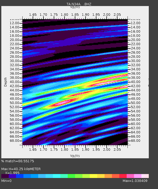
N34A Lincoln, NE, USA - Earthquake Result Viewer
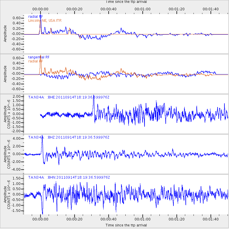
Earthquake location: Near Islands, Aleutian Islands
Earthquake latitude/longitude: 53.1/173.0
Earthquake time(UTC): 2011/09/14 (257) 18:10:09 GMT
Earthquake Depth: 15 km
Earthquake Magnitude: 6.1 MB, 5.7 MS, 6.0 MW, 6.0 MW
Earthquake Catalog/Contributor: WHDF/NEIC
Network: TA USArray Transportable Network (new EarthScope stations)
Station: N34A Lincoln, NE, USA
Lat/Lon: 40.84 N/96.50 W
Elevation: 401 m
Distance: 59.0 deg
Az: 62.309 deg
Baz: 315.283 deg
Ray Param: 0.06249044
Estimated Moho Depth: 40.25 km
Estimated Crust Vp/Vs: 2.00
Assumed Crust Vp: 6.498 km/s
Estimated Crust Vs: 3.257 km/s
Estimated Crust Poisson's Ratio: 0.33
Radial Match: 88.55175 %
Radial Bump: 400
Transverse Match: 73.89712 %
Transverse Bump: 400
SOD ConfigId: 414626
Insert Time: 2012-01-23 10:38:01.508 +0000
GWidth: 2.5
Max Bumps: 400
Tol: 0.001

Signal To Noise

ChannelStoNSTALTA
TA:N34A: :BHZ:20110914T18:19:36.599976Z19.354811.6955149E-68.7601734E-8
TA:N34A: :BHN:20110914T18:19:36.599976Z5.18405346.8309186E-71.317679E-7
TA:N34A: :BHE:20110914T18:19:36.599976Z5.3351327.883005E-71.4775651E-7
Arrivals
Ps6.4 SECOND
PpPs18 SECOND
PsPs/PpSs24 SECOND