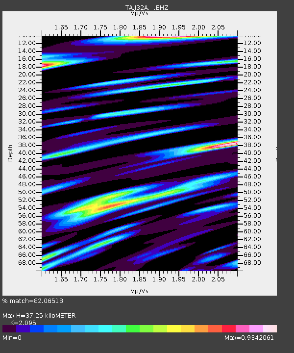
J32A Parkston, SD, USA - Earthquake Result Viewer
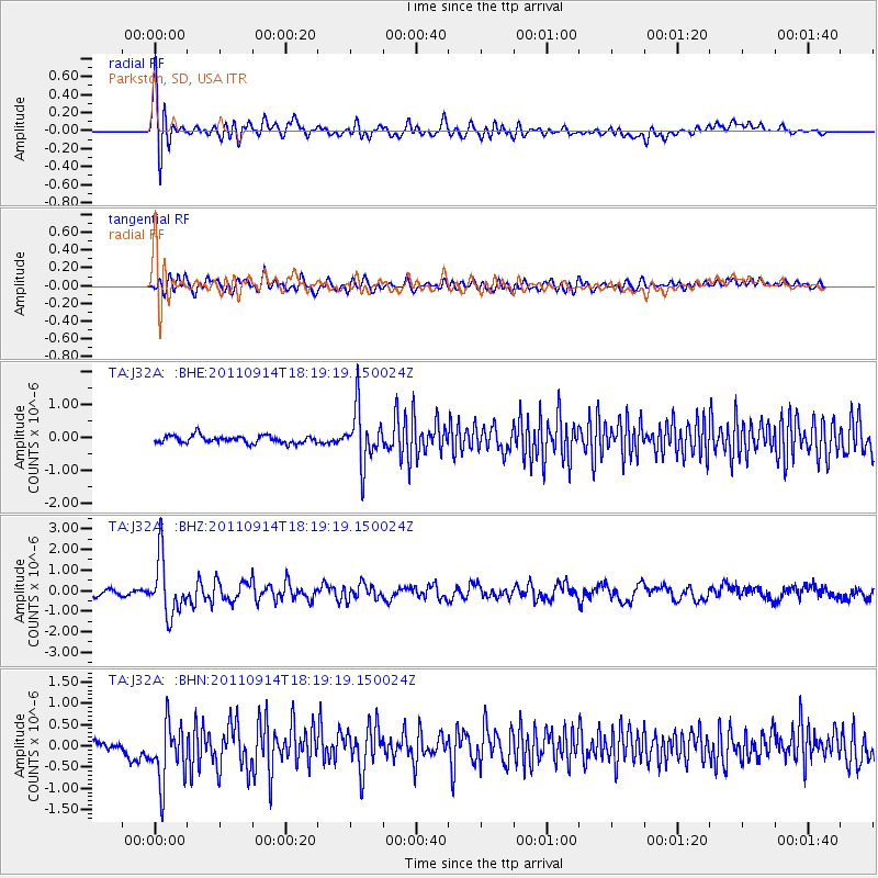
Earthquake location: Near Islands, Aleutian Islands
Earthquake latitude/longitude: 53.1/173.0
Earthquake time(UTC): 2011/09/14 (257) 18:10:09 GMT
Earthquake Depth: 15 km
Earthquake Magnitude: 6.1 MB, 5.7 MS, 6.0 MW, 6.0 MW
Earthquake Catalog/Contributor: WHDF/NEIC
Network: TA USArray Transportable Network (new EarthScope stations)
Station: J32A Parkston, SD, USA
Lat/Lon: 43.37 N/97.85 W
Elevation: 399 m
Distance: 56.5 deg
Az: 61.003 deg
Baz: 313.685 deg
Ray Param: 0.06410691
Estimated Moho Depth: 37.25 km
Estimated Crust Vp/Vs: 2.10
Assumed Crust Vp: 6.498 km/s
Estimated Crust Vs: 3.101 km/s
Estimated Crust Poisson's Ratio: 0.35
Radial Match: 82.06518 %
Radial Bump: 400
Transverse Match: 65.171906 %
Transverse Bump: 400
SOD ConfigId: 414626
Insert Time: 2012-01-23 10:41:49.245 +0000
GWidth: 2.5
Max Bumps: 400
Tol: 0.001

Signal To Noise

ChannelStoNSTALTA
TA:J32A: :BHZ:20110914T18:19:19.150024Z8.634331.3848078E-61.6038393E-7
TA:J32A: :BHN:20110914T18:19:19.150024Z5.96882447.362899E-71.2335595E-7
TA:J32A: :BHE:20110914T18:19:19.150024Z7.21100578.275209E-71.14758045E-7
Arrivals
Ps6.6 SECOND
PpPs17 SECOND
PsPs/PpSs24 SECOND