You are here: Home > Network List > TA - USArray Transportable Network (new EarthScope stations) Stations List
> Station I31A Royce, Wessington Springs, SD, USA > Earthquake Result Viewer
I31A Royce, Wessington Springs, SD, USA - Earthquake Result Viewer
| Earthquake location: |
Near Islands, Aleutian Islands |
| Earthquake latitude/longitude: |
53.1/173.0 |
| Earthquake time(UTC): |
2011/09/14 (257) 18:10:09 GMT |
| Earthquake Depth: |
15 km |
| Earthquake Magnitude: |
6.1 MB, 5.7 MS, 6.0 MW, 6.0 MW |
| Earthquake Catalog/Contributor: |
WHDF/NEIC |
|
| Network: |
TA USArray Transportable Network (new EarthScope stations) |
| Station: |
I31A Royce, Wessington Springs, SD, USA |
| Lat/Lon: |
44.03 N/98.54 W |
| Elevation: |
469 m |
|
| Distance: |
55.7 deg |
| Az: |
60.84 deg |
| Baz: |
313.121 deg |
| Ray Param: |
0.064637 |
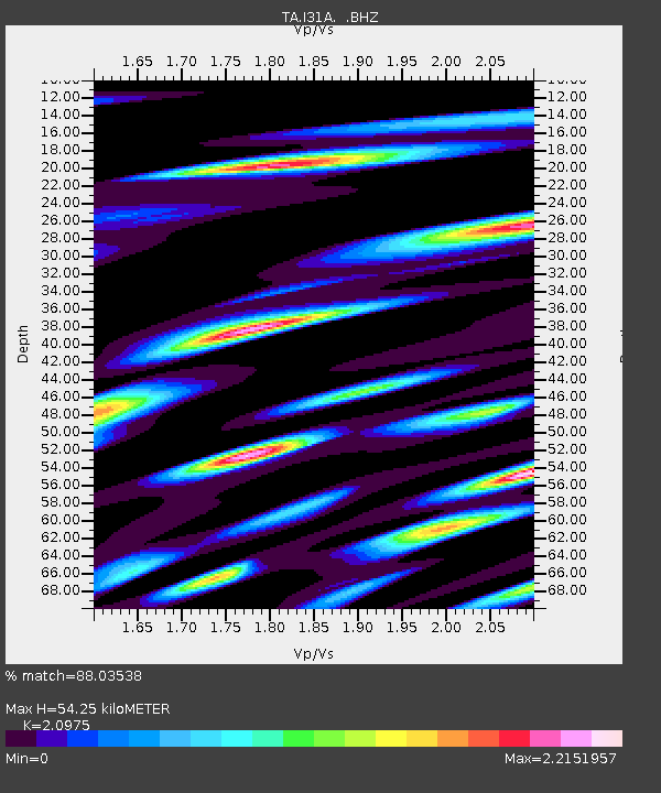
| Estimated Moho Depth: |
54.25 km |
| Estimated Crust Vp/Vs: |
2.10 |
| Assumed Crust Vp: |
6.53 km/s |
| Estimated Crust Vs: |
3.113 km/s |
| Estimated Crust Poisson's Ratio: |
0.35 |
|
| Radial Match: |
88.03538 % |
| Radial Bump: |
385 |
| Transverse Match: |
83.5593 % |
| Transverse Bump: |
400 |
| SOD ConfigId: |
414626 |
| Insert Time: |
2012-01-23 10:42:02.245 +0000 |
| GWidth: |
2.5 |
| Max Bumps: |
400 |
| Tol: |
0.001 |
|
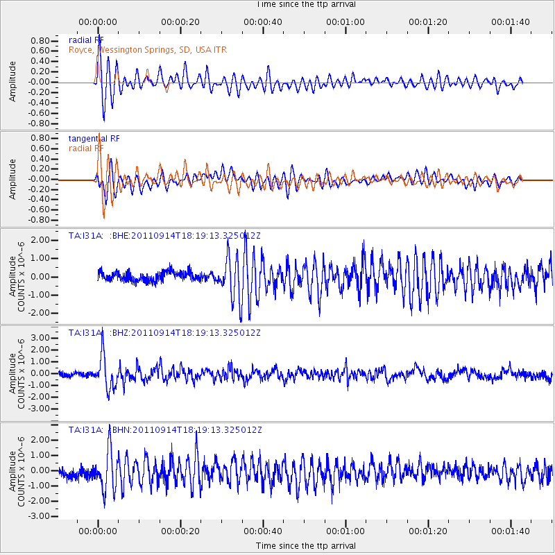
Signal To Noise
| Channel | StoN | STA | LTA |
| TA:I31A: :BHZ:20110914T18:19:13.325012Z | 7.196684 | 1.4040884E-6 | 1.9510213E-7 |
| TA:I31A: :BHN:20110914T18:19:13.325012Z | 3.9419174 | 1.3154637E-6 | 3.3371165E-7 |
| TA:I31A: :BHE:20110914T18:19:13.325012Z | 4.808591 | 1.1702815E-6 | 2.4337308E-7 |
| Arrivals |
| Ps | 9.5 SECOND |
| PpPs | 25 SECOND |
| PsPs/PpSs | 34 SECOND |


