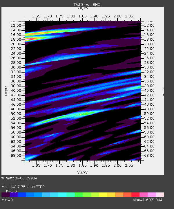
K34A Le Mars, IA, USA - Earthquake Result Viewer

Earthquake location: Near Islands, Aleutian Islands
Earthquake latitude/longitude: 53.1/173.0
Earthquake time(UTC): 2011/09/14 (257) 18:10:09 GMT
Earthquake Depth: 15 km
Earthquake Magnitude: 6.1 MB, 5.7 MS, 6.0 MW, 6.0 MW
Earthquake Catalog/Contributor: WHDF/NEIC
Network: TA USArray Transportable Network (new EarthScope stations)
Station: K34A Le Mars, IA, USA
Lat/Lon: 42.69 N/96.10 W
Elevation: 436 m
Distance: 57.9 deg
Az: 60.523 deg
Baz: 314.616 deg
Ray Param: 0.0632014
Estimated Moho Depth: 17.75 km
Estimated Crust Vp/Vs: 1.60
Assumed Crust Vp: 6.498 km/s
Estimated Crust Vs: 4.061 km/s
Estimated Crust Poisson's Ratio: 0.18
Radial Match: 88.29934 %
Radial Bump: 400
Transverse Match: 72.39003 %
Transverse Bump: 400
SOD ConfigId: 414626
Insert Time: 2012-01-23 10:42:21.683 +0000
GWidth: 2.5
Max Bumps: 400
Tol: 0.001

Signal To Noise

ChannelStoNSTALTA
TA:K34A: :BHZ:20110914T18:19:29.000Z16.546342.3914697E-61.4453163E-7
TA:K34A: :BHN:20110914T18:19:29.000Z3.41292121.1773243E-63.4496085E-7
TA:K34A: :BHE:20110914T18:19:29.000Z8.6214271.4954865E-61.7346159E-7
Arrivals
Ps1.7 SECOND
PpPs6.7 SECOND
PsPs/PpSs8.4 SECOND