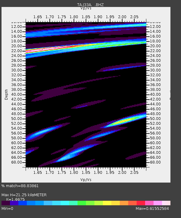
J33A Davis, SD, USA - Earthquake Result Viewer

Earthquake location: Near Islands, Aleutian Islands
Earthquake latitude/longitude: 53.1/173.0
Earthquake time(UTC): 2011/09/14 (257) 18:10:09 GMT
Earthquake Depth: 15 km
Earthquake Magnitude: 6.1 MB, 5.7 MS, 6.0 MW, 6.0 MW
Earthquake Catalog/Contributor: WHDF/NEIC
Network: TA USArray Transportable Network (new EarthScope stations)
Station: J33A Davis, SD, USA
Lat/Lon: 43.32 N/96.97 W
Elevation: 400 m
Distance: 57.0 deg
Az: 60.516 deg
Baz: 314.021 deg
Ray Param: 0.06377854
Estimated Moho Depth: 21.25 km
Estimated Crust Vp/Vs: 1.67
Assumed Crust Vp: 6.498 km/s
Estimated Crust Vs: 3.897 km/s
Estimated Crust Poisson's Ratio: 0.22
Radial Match: 88.83861 %
Radial Bump: 400
Transverse Match: 64.91414 %
Transverse Bump: 400
SOD ConfigId: 414626
Insert Time: 2012-01-23 10:42:33.781 +0000
GWidth: 2.5
Max Bumps: 400
Tol: 0.001

Signal To Noise

ChannelStoNSTALTA
TA:J33A: :BHZ:20110914T18:19:22.674988Z13.6612751.53532E-61.1238483E-7
TA:J33A: :BHN:20110914T18:19:22.674988Z4.09084947.0556797E-71.7247469E-7
TA:J33A: :BHE:20110914T18:19:22.674988Z3.33046.960375E-72.0899516E-7
Arrivals
Ps2.3 SECOND
PpPs8.3 SECOND
PsPs/PpSs11 SECOND