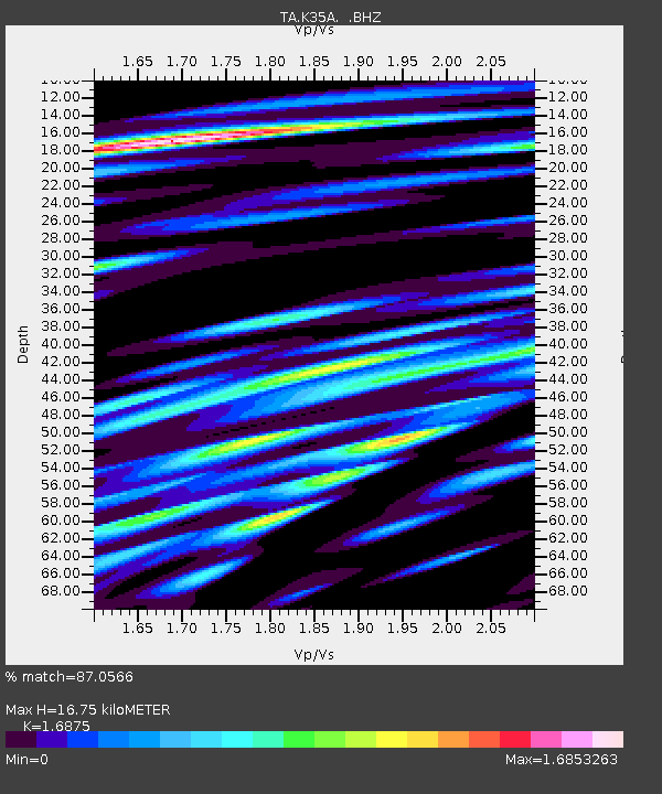
K35A Storm Lake, IA, USA - Earthquake Result Viewer
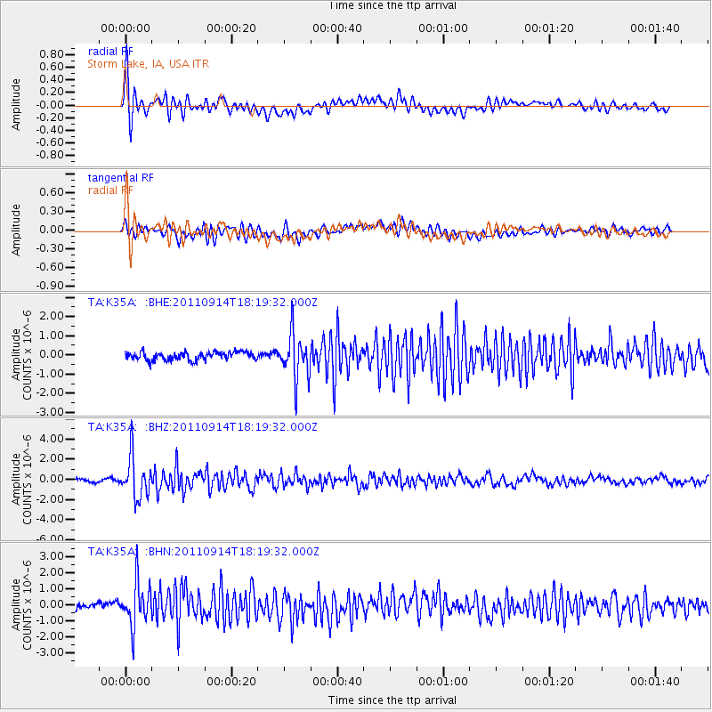
Earthquake location: Near Islands, Aleutian Islands
Earthquake latitude/longitude: 53.1/173.0
Earthquake time(UTC): 2011/09/14 (257) 18:10:09 GMT
Earthquake Depth: 15 km
Earthquake Magnitude: 6.1 MB, 5.7 MS, 6.0 MW, 6.0 MW
Earthquake Catalog/Contributor: WHDF/NEIC
Network: TA USArray Transportable Network (new EarthScope stations)
Station: K35A Storm Lake, IA, USA
Lat/Lon: 42.72 N/95.23 W
Elevation: 439 m
Distance: 58.3 deg
Az: 59.966 deg
Baz: 314.905 deg
Ray Param: 0.06292322
Estimated Moho Depth: 16.75 km
Estimated Crust Vp/Vs: 1.69
Assumed Crust Vp: 6.53 km/s
Estimated Crust Vs: 3.87 km/s
Estimated Crust Poisson's Ratio: 0.23
Radial Match: 87.0566 %
Radial Bump: 400
Transverse Match: 74.82191 %
Transverse Bump: 400
SOD ConfigId: 414626
Insert Time: 2012-01-23 10:42:47.550 +0000
GWidth: 2.5
Max Bumps: 400
Tol: 0.001

Signal To Noise

ChannelStoNSTALTA
TA:K35A: :BHZ:20110914T18:19:32.000Z13.9623662.0242035E-61.4497567E-7
TA:K35A: :BHN:20110914T18:19:32.000Z6.6855971.3870031E-62.0746135E-7
TA:K35A: :BHE:20110914T18:19:32.000Z5.62327241.1767758E-62.0926885E-7
Arrivals
Ps1.9 SECOND
PpPs6.5 SECOND
PsPs/PpSs8.4 SECOND