You are here: Home > Network List > TA - USArray Transportable Network (new EarthScope stations) Stations List
> Station C33A Trail, MN, USA > Earthquake Result Viewer
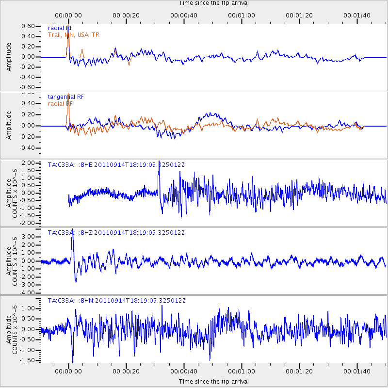
C33A Trail, MN, USA - Earthquake Result Viewer
*The percent match for this event was below the threshold and hence no stack was calculated.
| Earthquake location: |
Near Islands, Aleutian Islands |
| Earthquake latitude/longitude: |
53.1/173.0 |
| Earthquake time(UTC): |
2011/09/14 (257) 18:10:09 GMT |
| Earthquake Depth: |
15 km |
| Earthquake Magnitude: |
6.1 MB, 5.7 MS, 6.0 MW, 6.0 MW |
| Earthquake Catalog/Contributor: |
WHDF/NEIC |
|
| Network: |
TA USArray Transportable Network (new EarthScope stations) |
| Station: |
C33A Trail, MN, USA |
| Lat/Lon: |
47.76 N/95.77 W |
| Elevation: |
388 m |
|
| Distance: |
54.5 deg |
| Az: |
55.903 deg |
| Baz: |
312.274 deg |
| Ray Param: |
$rayparam |
*The percent match for this event was below the threshold and hence was not used in the summary stack. |
|
| Radial Match: |
73.92931 % |
| Radial Bump: |
400 |
| Transverse Match: |
62.365517 % |
| Transverse Bump: |
400 |
| SOD ConfigId: |
414626 |
| Insert Time: |
2012-01-23 10:45:03.459 +0000 |
| GWidth: |
2.5 |
| Max Bumps: |
400 |
| Tol: |
0.001 |
|
Signal To Noise
| Channel | StoN | STA | LTA |
| TA:C33A: :BHZ:20110914T18:19:05.325012Z | 10.920107 | 1.5553395E-6 | 1.4242896E-7 |
| TA:C33A: :BHN:20110914T18:19:05.325012Z | 2.9479012 | 5.445386E-7 | 1.8472076E-7 |
| TA:C33A: :BHE:20110914T18:19:05.325012Z | 3.0078053 | 6.780454E-7 | 2.2542862E-7 |
| Arrivals |
| Ps | |
| PpPs | |
| PsPs/PpSs | |


