C06D Leavenworth, WQ, USA - Earthquake Result Viewer
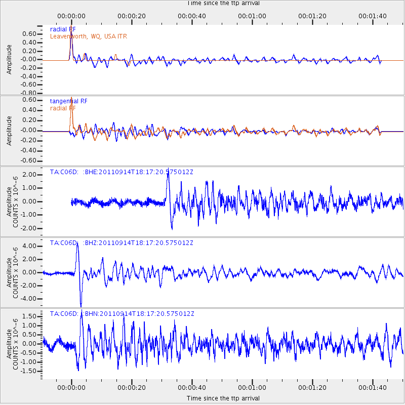
Earthquake location: Near Islands, Aleutian Islands
Earthquake latitude/longitude: 53.1/173.0
Earthquake time(UTC): 2011/09/14 (257) 18:10:09 GMT
Earthquake Depth: 15 km
Earthquake Magnitude: 6.1 MB, 5.7 MS, 6.0 MW, 6.0 MW
Earthquake Catalog/Contributor: WHDF/NEIC
Network: TA USArray Transportable Network (new EarthScope stations)
Station: C06D Leavenworth, WQ, USA
Lat/Lon: 47.92 N/120.89 W
Elevation: 544 m
Distance: 41.0 deg
Az: 69.584 deg
Baz: 302.854 deg
Ray Param: 0.0740426
Estimated Moho Depth: 25.25 km
Estimated Crust Vp/Vs: 1.64
Assumed Crust Vp: 6.597 km/s
Estimated Crust Vs: 4.029 km/s
Estimated Crust Poisson's Ratio: 0.20
Radial Match: 82.35116 %
Radial Bump: 400
Transverse Match: 73.25216 %
Transverse Bump: 400
SOD ConfigId: 414626
Insert Time: 2012-01-23 10:45:42.606 +0000
GWidth: 2.5
Max Bumps: 400
Tol: 0.001

Signal To Noise

ChannelStoNSTALTA
TA:C06D: :BHZ:20110914T18:17:20.575012Z21.1240732.1986687E-61.04083554E-7
TA:C06D: :BHN:20110914T18:17:20.575012Z5.23607068.225808E-71.5709888E-7
TA:C06D: :BHE:20110914T18:17:20.575012Z6.57172061.0293722E-61.5663664E-7
Arrivals
Ps2.6 SECOND
PpPs9.3 SECOND
PsPs/PpSs12 SECOND