You are here: Home > Network List > TA - USArray Transportable Network (new EarthScope stations) Stations List
> Station H37A Dierke Farm, Cannon Falls, MN, USA > Earthquake Result Viewer
H37A Dierke Farm, Cannon Falls, MN, USA - Earthquake Result Viewer
| Earthquake location: |
Near Islands, Aleutian Islands |
| Earthquake latitude/longitude: |
53.1/173.0 |
| Earthquake time(UTC): |
2011/09/14 (257) 18:10:09 GMT |
| Earthquake Depth: |
15 km |
| Earthquake Magnitude: |
6.1 MB, 5.7 MS, 6.0 MW, 6.0 MW |
| Earthquake Catalog/Contributor: |
WHDF/NEIC |
|
| Network: |
TA USArray Transportable Network (new EarthScope stations) |
| Station: |
H37A Dierke Farm, Cannon Falls, MN, USA |
| Lat/Lon: |
44.58 N/92.92 W |
| Elevation: |
321 m |
|
| Distance: |
58.2 deg |
| Az: |
57.023 deg |
| Baz: |
314.948 deg |
| Ray Param: |
0.06300331 |
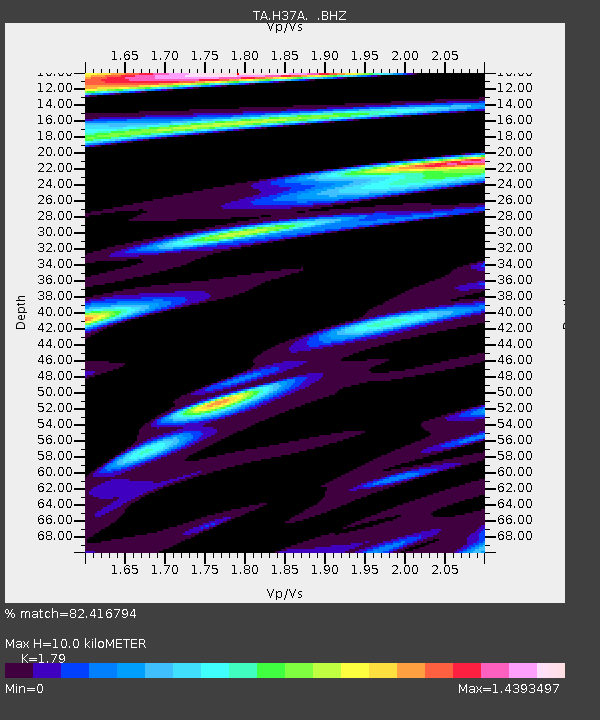
| Estimated Moho Depth: |
10.0 km |
| Estimated Crust Vp/Vs: |
1.79 |
| Assumed Crust Vp: |
6.571 km/s |
| Estimated Crust Vs: |
3.671 km/s |
| Estimated Crust Poisson's Ratio: |
0.27 |
|
| Radial Match: |
82.416794 % |
| Radial Bump: |
400 |
| Transverse Match: |
64.97985 % |
| Transverse Bump: |
400 |
| SOD ConfigId: |
414626 |
| Insert Time: |
2012-01-23 10:47:23.665 +0000 |
| GWidth: |
2.5 |
| Max Bumps: |
400 |
| Tol: |
0.001 |
|

Signal To Noise
| Channel | StoN | STA | LTA |
| TA:H37A: :BHZ:20110914T18:19:31.125Z | 12.684463 | 2.8019927E-6 | 2.208996E-7 |
| TA:H37A: :BHN:20110914T18:19:31.125Z | 2.7455506 | 9.662884E-7 | 3.5194705E-7 |
| TA:H37A: :BHE:20110914T18:19:31.125Z | 2.8743804 | 9.2331436E-7 | 3.2122205E-7 |
| Arrivals |
| Ps | 1.3 SECOND |
| PpPs | 4.0 SECOND |
| PsPs/PpSs | 5.3 SECOND |


