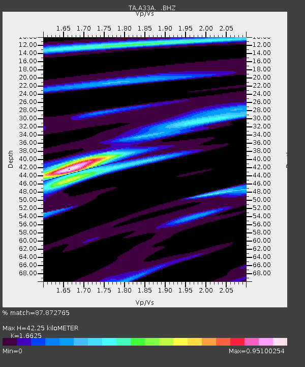
A33A Warroad, MN, USA - Earthquake Result Viewer
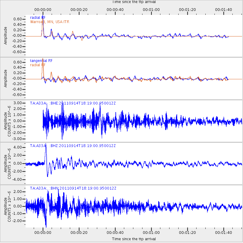
Earthquake location: Near Islands, Aleutian Islands
Earthquake latitude/longitude: 53.1/173.0
Earthquake time(UTC): 2011/09/14 (257) 18:10:09 GMT
Earthquake Depth: 15 km
Earthquake Magnitude: 6.1 MB, 5.7 MS, 6.0 MW, 6.0 MW
Earthquake Catalog/Contributor: WHDF/NEIC
Network: TA USArray Transportable Network (new EarthScope stations)
Station: A33A Warroad, MN, USA
Lat/Lon: 48.94 N/95.39 W
Elevation: 329 m
Distance: 53.9 deg
Az: 54.614 deg
Baz: 311.805 deg
Ray Param: 0.06574553
Estimated Moho Depth: 42.25 km
Estimated Crust Vp/Vs: 1.66
Assumed Crust Vp: 6.419 km/s
Estimated Crust Vs: 3.861 km/s
Estimated Crust Poisson's Ratio: 0.22
Radial Match: 87.872765 %
Radial Bump: 357
Transverse Match: 67.63905 %
Transverse Bump: 400
SOD ConfigId: 414626
Insert Time: 2012-01-23 10:47:25.887 +0000
GWidth: 2.5
Max Bumps: 400
Tol: 0.001

Signal To Noise

ChannelStoNSTALTA
TA:A33A: :BHZ:20110914T18:19:00.950012Z7.3845641.9325203E-62.616973E-7
TA:A33A: :BHN:20110914T18:19:00.950012Z1.81436691.1073004E-66.1029573E-7
TA:A33A: :BHE:20110914T18:19:00.950012Z1.21074241.1257249E-69.2978075E-7
Arrivals
Ps4.6 SECOND
PpPs17 SECOND
PsPs/PpSs21 SECOND