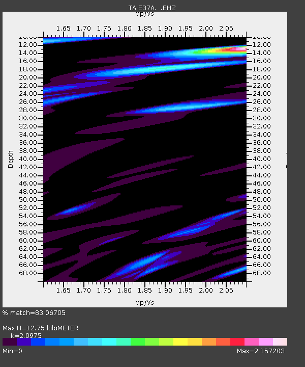
E37A Wrenshall, MN, USA - Earthquake Result Viewer

Earthquake location: Near Islands, Aleutian Islands
Earthquake latitude/longitude: 53.1/173.0
Earthquake time(UTC): 2011/09/14 (257) 18:10:09 GMT
Earthquake Depth: 15 km
Earthquake Magnitude: 6.1 MB, 5.7 MS, 6.0 MW, 6.0 MW
Earthquake Catalog/Contributor: WHDF/NEIC
Network: TA USArray Transportable Network (new EarthScope stations)
Station: E37A Wrenshall, MN, USA
Lat/Lon: 46.57 N/92.40 W
Elevation: 304 m
Distance: 57.0 deg
Az: 55.047 deg
Baz: 314.258 deg
Ray Param: 0.06373407
Estimated Moho Depth: 12.75 km
Estimated Crust Vp/Vs: 2.10
Assumed Crust Vp: 6.571 km/s
Estimated Crust Vs: 3.133 km/s
Estimated Crust Poisson's Ratio: 0.35
Radial Match: 83.06705 %
Radial Bump: 400
Transverse Match: 65.4949 %
Transverse Bump: 400
SOD ConfigId: 414626
Insert Time: 2012-01-23 10:48:33.492 +0000
GWidth: 2.5
Max Bumps: 400
Tol: 0.001

Signal To Noise

ChannelStoNSTALTA
TA:E37A: :BHZ:20110914T18:19:23.174988Z11.1658692.7640863E-62.475478E-7
TA:E37A: :BHN:20110914T18:19:23.174988Z2.7448612.0810721E-67.581703E-7
TA:E37A: :BHE:20110914T18:19:23.174988Z4.13527771.971762E-64.768149E-7
Arrivals
Ps2.2 SECOND
PpPs5.8 SECOND
PsPs/PpSs8.0 SECOND